The commercial drone ecosystem has a problem: walled gardens. There are numerous examples of this from all sides of the ecosystem. Whether it’s hardware companies keeping proprietary sets of data to limit flight capabilities or UTM ‘providers’ aggregating unofficial no-fly zones that exist only within their applications. The market has spoken clearly in the past decade in the commercial drone industry: The walled garden approach is doomed to fail. The only real way to foster innovation and adoption is to create a climate of collaboration. Just imagine if each major airline had their own airports. Or if your favorite airline was banned from flying over certain states. Chaos would rein and the entire ecosystem would suffer. This is what’s happening in the commercial drone industry.
We believe that the biggest winners are going to be the ones who make data easily accessible to large and small stakeholders alike. Decision making data shouldn’t be hard to come by, hard to integrate, or expensive to acquire. That’s why we’ve been developing the Aloft Airspace API to make all of the excellent data in B4UFly available programmatically. This includes data for: Class Airspace, Airports, TFR’s, Stadiums, NSUFRs, DOD, and other restricted areas.
We’ve been hearing a lot of great use cases people have been using the Aloft API to programmatically integrate high-quality airspace information into their applications and workflows. These deep integrations allow for better decision making, lower operational overhead, and increased automation. Fortune 500 companies can securely integrate this data into your custom applications. Drone hardware companies can natively tie in official airspace data to flight controls. However, it doesn’t take a team of developers and fancy enterprise software to see value from our API. You can use it right in everyday tools like Microsoft Office, Google Sheets or ESRI.
Over the years, we’ve had to come up with creative solutions to help process large amounts of airspace data in various hostile formats. Now, with the Aloft Airspace API, you can add airspace as a native function like SUM() and have your spreadsheets seamlessly interact with our Airspace API.
First, you’ll need to sign up for the API. It’s pay-as-you go and each request costs just $.01. You’ll need to input your credit card, subscribe to the pay as you go plan and make note of your API key.
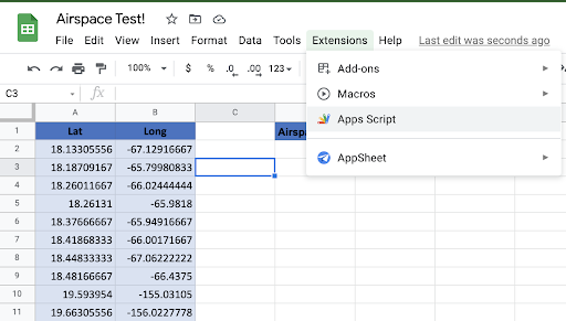
You can just clone this to your account or, if you’d like to do it by hand: click on Extensions and select Apps Scripts.
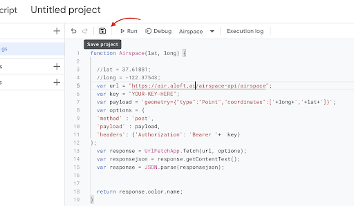
In the Code.gs editor, paste the contents from this Gist, with your key edited in. Then hit the floppy disk to save the code.
That’s it!
You now have two brand new functions to use inside of Google Sheets. Both take the same argument: Latitude and Longitude.
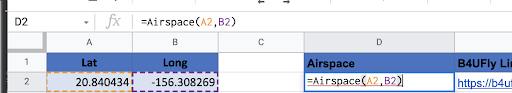
To determine the airspace, you’ll go ahead and type =Airspace(Latitude,Longitude). This will return a color.
Blue is controlled.
Green is Good to Go.
Yellow is proceed with caution because airports/stadiums/heliports are in the area.
Red, naturally, is for TFR’s, DOD NSUFR, FRZ, and generally “NO GO” areas.
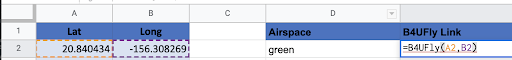
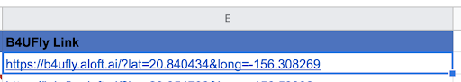
Colors are great for quick information, but what if you want to research more about why it holds that designation? Simply go to any cell, and type =B4UFly(Latitude,Longitude) and you’ll get back a link to the B4UFly web interface for that location.
Now, you can just drag and drop your way to airspace intelligence. This is great if you want to process large volumes of data right in Sheets or if you need to check the airspace data everyday for a large list of sites. No programming experience required.
Now, you can just drag and drop your way to airspace intelligence. This is great if you want to process large volumes of data right in Sheets or if you need to check the airspace data everyday for a large list of sites. No programming experience required.
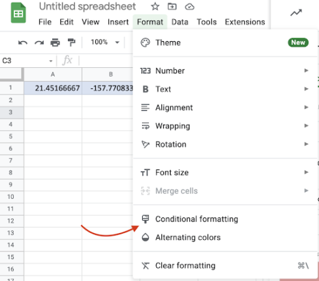
If you want to get really fancy, you can style the spreadsheet visually for easy reference. From the top menu, select Format then Conditional Formatting.
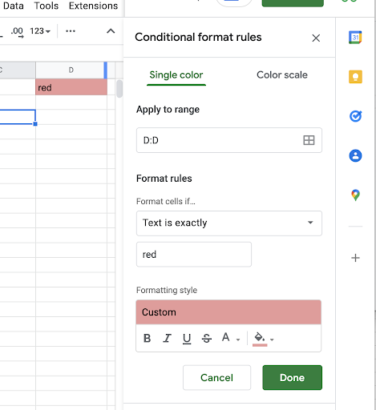
Then we’ll input which column the airspace information lives. In this example it’s D. Then set it to match the airspace color and what color it should make the cell. Then rinse and repeat for each of the four airspace colors.
It’s all live now and available today. If you’re looking to add airspace intelligence to your enterprise workflow, your application, or want to know more about what programmatic options Aloft has available, get in touch.
Watch the webinar below on-demand with Aloft CTO and Founder, Joshua Ziering to learn more about the Aloft Airspace API.


