Feel like taking a quick drone flight over Lady Liberty? Not so fast says the FAA.
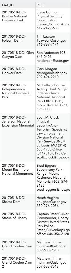
The FAA, at the behest of national security and law enforcement has issued new restrictions to prevent unauthorized drone operations over 10 landmarks managed by the Department of the Interior. This includes the Hoover Dam, The Statue of Liberty and Mount Rushmore. Here’s the full list along with points of contact for those locations:
What is the Department of the Interior?
The United States Department of the Interior (DOI) is responsible for the management of federal land and natural resources. It manages almost 75% of the federal public land.
The DOI is a sort of ‘catch-all’ for issues that don’t fit neatly into other departments in the government. In Washington parlance, the DOI is sometimes referred to as the “Department of Everything Else” or “Department of Everything” because of their wide mission statement and broad managerial oversight.
But What if I’m Part 107?
Without prior ok, you’re still out of luck. Even if the surrounding airspace is Class G, the areas outlined by the FAA are all prohibited. We’ve collected all 10 sites and will be adding them to the app in the coming weeks so that our users will always have the most up to date information right in the app. If you’re looking for who to contact about getting a waiver, we’ll be adding that information in coming weeks as well, but for now you can visit the FAA map, which includes points of contact.
https://faa.maps.arcgis.com/apps/webappviewer/index.html?id=9c2e4406710048e19806ebf6a06754ad
When does all this start?
These restrictions become effective October 5th, 2017.
As always, Kittyhawk is monitoring the drone industry for developments and working to bring the most timely and up to date information to our users.
Kittyhawk is free: download the iOS or Android apps.


