When, Where & How to Fly Drones Safely During the Eclipse
What if you had the chance to film something 55 miles wide traveling just over Mach 3 with your drone? As it turns out, on August 21st 2017, you’ll have that very opportunity. A solar eclipse, or alignment of the sun, moon and earth, is taking place for the first time in 38 years. The last cosmic event of this magnitude happened on February 26, 1979 — a time long before you could use the battery powered supercomputer in your pocket to fly a self-stabilizing GPS guided aircraft with a 4k camera using a high bandwidth spread spectrum wireless control system. Sheesh, drone’s sound so impressive when you describe them like that.
We had one of our commercial customers ask us, “What’s involved in flying a drone during the eclipse?” and after batting the idea around the office we set our Chief Pilot Josh Ziering loose on the question. He had more than a few recommendations.
We’ve compiled a state by state list of the best places to fly in states that will get a full eclipse as well as some of the consideration involved if you’ll be flying commercially. (The title of Chief Pilot doesn’t come easy around here.)
A Word On Safety
A solar eclipse is a beautiful event but it comes with it’s own set of safety considerations. As with any mission, thorough planning and pre-flight is going to pay dividends in safety. Remember that in addition to the hostile environment, you might be contending with people nearby, unfamiliar surroundings, and strange flight conditions. Whether you’re flying commercially or as a hobbyist, you’ll still want to follow FAA guidelines and consider things like “flying at night” even when its high noon.
Also, no mission is worth losing your eye sight over. A solar eclipse can leave you visually impaired or blind for the rest of your life from even a brief glimpse at the sun. Make sure you and your visual observer both take the necessary precautions. NASA has a great web page on Eclipse Safety available to you here. https://eclipse2017.nasa.gov/safety
Oregon: Always too cool before it’s cool.
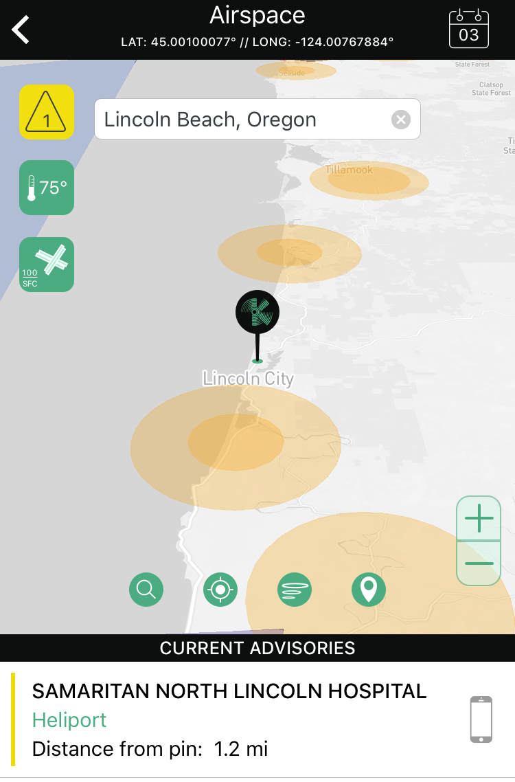
If you want to be the absolute first person to get footage of the shadow, the first land based point of contact with the path of totality (the shadow of the moon on the earth) will be at Lincoln Beach, Oregon at 9:05 a.m. PT. Even the planets know that if you want to be cool before it’s cool you start in Oregon.
Unfortunately, Lincoln Beach often suffers the same visibility problems that plague many coastal areas, particularly earlier in the day. If you don’t want to roll the dice, you’re better off moving inland where the chance for marine layer visual obscuration is much lower. If you’re flying commercially, remember that FAA Part 107 requires a minimum of 3 miles of visibility unless you have a waiver. Also remember that Oregon requires a separate registration for UAS (More on that below.)
Over 90 minutes the path of totality will run through Oregon, Idaho, Wyoming, Montana, Nebraska, Iowa, Kansas, Missouri, Illinois, Kentucky, Tennessee, Georgia, and North and South Carolina. The total eclipse will end near Charleston, South Carolina at 2:48 p.m. ET.
For detailed flight conditions and local rules for each state, continue reading below. We humbly present, in order of appearance, some fantastic places to fly.
Oregon
As mentioned above, Oregon has some pretty stuffy drone rules. They require any commercial aircraft (Even UAS to register) if they’re operating in Oregon. Here’s a link to the Oregon website for that: https://www.oregon.gov/aviation/Pages/index.aspx
Coastal areas of Portland are also notorious for their poor visibility and relatively frigid summer temperatures. It’s not exactly a sure bet for making sure you get once in a lifetime footage.
Many of the places defined as “the best” the watch the Eclipse from are the beautiful Oregon State Parks. While National Parks have a clear policy on drones, Oregon State Parks do not. It would be prudent to check in advance with the park officials you’re looking to fly in to make sure they allow drones. When working gigs like this, it’s usually a best practice to get something in writing and either throw it in your Kittyhawk Documents or keep a printed out copy with you.
https://www.oregonlive.com/travel/index.ssf/2017/03/17_places_to_watch_the_2017_so.html
WARNINGS:

Idaho
Idaho State Drone Laws: https://legislature.idaho.gov/statutesrules/idstat/Title21/T21CH2/SECT21-213/
Best Spots
Idaho Falls and Rexburg will experience a total eclipse of 1 minute 46 seconds and 2 minutes 17 seconds respectively. Unfortunately, Idaho Falls is almost all Class E airspace to the ground. However, the neighboring town of Mitchell has beautifully clear airspace and skies, which has been described by EclipseMobile.com as an “exceptionally cloud-free environment of the Columbia Basin.”
If you’re looking for somewhere you can camp, Smith’s Ferry Idaho has an entire event planned and they lie just outside of any nearby airspace. They also have a huge open field that’s likely to compete with just about any map on any flight simulator out there for “gorgeous points.”
WARNINGS:
Wyoming
Wyoming has no state specific drone laws to be weary of. (Though, they’ve tried and failed 4x to set up some state specific legislation that would likely be very damaging to the commercial drone industry there.)
Best Spots
- Casper
Casper is a town of almost 60,000 people that has quite a bit of uncontrolled airspace. When the team was researching places to fly, all of us were extremely impressed at their Eclipse Festival Website. Even if you’re not going to Casper for the big day, make sure you check out their website which is full of fun facts and even some beautiful drone shots of the North Platte River. https://eclipsecasper.com/ - Guernsey
This small town in rural Wyoming provides plenty of open spaces and open airspace for you to get your shot. The website is a little sparse but they provide contact information for you to get in touch with folks who may be able to help you find a good place to stay or stage from. https://www.townofguernseywy.us/index.asp?SEC=287E0125-7625-44B5-B25A-AB664F0750A0&Type=B_BASIC
WARNINGS:
Montana
No drone laws applied to civilians. Only law enforcement.
Only a small portion of Montana is going to be within the Umbral Shadow and unfortunately that portion is in a very inaccessible and uninhabited part of Montana. You’re much better off making the trip to Idaho or Wyoming to see the eclipse.
Nebraska
No specific state laws but the state capital has some restrictions you might need to be aware of. The state capital has released an operations guide you’ll need to adhere to in addition to Part 107.
Though there are no state laws, there is some local legislation you’ll want to be aware of. For example, Lincoln has a “responsible operator” law on the books. If you violate it, you’re looking at a hefty $100 fine, in addition to the hassle of having to deal with that.
Best Spots
A very long stretch of Interstate 80 from before North Platte to the edges of Lincoln is within the path of totality. Lincoln has a phenomenal page with lots of information about how to enjoy the eclipse there. Lincoln proudly touts their 125 neighborhood parks or 131 miles of trails. Learn more: https://www.lincoln.org/play/eclipse
One important note is that Lincoln has a baseball team, The Lincoln Salt Dogs, and they will be playing during the solar eclipse. As with any professional sporting event, this means an implied 3 mile TFR around the stadium from an hour before until an hour after. Even though it’s not indicated on this map, you’ll want to be cognizant of that and respectful of it.
Amendment: The Salt Dogs actually aren’t a major league baseball team and their stadium only holds 8,500 people … far below the 30,000 person threshold for a stadium TFR. See https://www.faasafety.gov/gslac/ALC/course_content.aspx?cID=42&sID=240&preview=true for more information.
WARNINGS:

Iowa
If you’re looking for a good spot to watch in Iowa, your options are unfortunately very limited. Iowa is getting the smallest sliver of the eclipse in the US. Moreover, the only part of Iowa that’s going to be able to view the eclipse is not accessible by roads.
Best Spots Nearby
- St. Joseph, Mo., is 2 1/2 hours from Des Moines, Iowa. St. Joseph is the fifth-largest city in the eclipse path.
Kansas
If you are harassing/stalking someone while trying to get your eclipse footage, you stand to get in some trouble. Whether or not filming an eclipse could be considered harassment is unfortunately up to some interpretation.
https://kslegislature.org/li_2016/b2015_16/measures/documents/sb319_enrolled.pdf
Best Spots
- Hiawatha, KS
In and around Hiawatha there is plenty of Class G airspace you can fly in and from the looks of it, a lot of enthusiastic Eclipser’s looking to revel in the shadow. You can learn more about Brown County’s plans and what’s happening in Hiawatha here: https://www.facebook.com/BrownCountyBlackout/
There are plenty of spots along I-70 on either the west or east side of Kansas City that would prove ideal for a little flying and filming.
Missouri
No prohibitive local drone laws for people trying to capture some footage.
Best Spots
- Chesterfield
Chesterfield will provide ample places to operate from. All along Interstate 64 will be in the shadow and has ample opportunities. Chesterfield is a neighboring city to St. Louis. - Kirkwood
Kirkwood has lots of Class G airspace and is far from any airports around. Kirkwood is also home to lots of beautiful parks that may serve as a great place to operate from as long as you’re not flying over people. The Kirkwood MO website lists no regulations or rules about operating sUAS out of their parks.
Illinois
State Drone Laws: No laws affecting civilian or commercial operators.
Best Spots
- Waterloo, IL (Monroe County Fairgrounds)
All of Waterloo, IL is in Class G airspace and they don’t have any local ordinances prohibiting the operation of sUAS aircraft. Their municipal website has a lot of information on what’s going on and how you can be apart of it! https://www.waterloo.il.us/ - Makanda, IL (Blue Sky Vineyard, Rated 4.6/5 by Zagats)
NASA has calculated that the longest point of duration for viewing the 2017 eclipse is in Illinois near this beautiful winery. As a drone pilot, it’s hard not to like a place called Blue Sky Vineyard. As a fans of irony, it’s hard not to like watching a total solar eclipse at a place called Blue Sky Vineyard. Here’s a link to their event page: https://www.blueskyvineyard.com/events2/
Kentucky
State Drone Laws: No state laws to note.
Best Spot
- Paducah KY
Situated on the banks of the Ohio River, Paducah is a city of about 25,000. They are welcoming visitors to their town with open arms and open airspace. https://paducahky.gov/solar-eclipse-2017
Tennessee
TN has some dubious sounding drone laws. For example, you can take pictures or video “With the consent of the individual who owns or lawfully occupies the real property captured in the image” … So maybe best to call ahead and make sure you’re doing the right thing.
Nashville is going to be in the path totality and will be a good place if you can find some uncontrolled airspace. However, it seems like it’s going to be pretty busy.
All these places seem like they’ll be NO fly zones but if you call ahead and verify, you might be able to get some flights in, depending on the place. https://www.knoxnews.com/story/news/local/tennessee/2017/08/02/22-places-east-tennessee-watch-2017-solar-eclipse/514449001/
Georgia
State Drone Laws: No state specific laws, but some minor resolutions.
Best Spots
- Clayton, GA https://www.exploregeorgia.org/city/clayton
- Toccoa, GA https://www.cityoftoccoa.com/
North Carolina
To fly commercially you’ll need a part 107, and a permit from the NCDOT which requires passing ANOTHER knowledge test to get. Here’s more information: https://www.ncdot.gov/aviation/uas/requirements/
Best Spot
- Murphy, NC — https://www.visitnc.com/event/2017-solar-eclipse-in-cherokee-county
South Carolina
No state level drone laws have been passed in South Carolina.
Best Spot
- Charleston, South Carolina
Charleston is our pick for the best spot in South Carolina. The Charleston Harbor provides plenty of room to operate and resides squarely in Class G airspace. Not to mention the breathtaking views of the bridge and water that are possible.
In addition to being the last possible place to see the eclipse on land, Charleston has a wide variety of places to operate from and has a very conducive climate for operating drones in the summer time.
To Clear Skies and Safe Landings!
The solar eclipse promises to be a show from the ground or the air. Remember, there are going to be a lot of people trying to enjoy the eclipse that aren’t familiar with drones. An operator that is respectful is a good ambassador for our burgeoning industry. When you’ve got your footage in the can, make sure to share it with @Kittyhawkio on Twitter so we can see too!
If you have any suggestions, corrections, or would like to submit places you think should be on this list but aren’t, we’re always happy to hear from our readers.
Special Thanks
“Thank You” to AirMap and Jonathan Rupprecht for his useful state-by-state collection of drone laws.


