Hey Kittyhawkers!
It’s been a cold winter all over the country. Cold temperatures. Cold batteries. Cold phones. We get it. That’s why we’ve been busy trying to bring the heat of brand new enterprise features to you. If the winter weather has left you longing for some new Kittyhawk goodness, look no further.
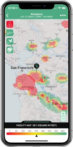
New Native FAA UAS Facility Maps
Kittyhawk continues to work on our LAANC integration that will embrace our belief that a true enterprise solution needs to be a one-stop-shop. To be effective, LAANC has to be more than just an authorization, and we’re building in features, visibility and compliance throughout your workflows.
In anticipation of the larger LAANC announcement, we’ve created a new map layer that shows all 500 or so FAA UAS Facility Maps. Each square is color coded according to the maximum altitude you’re allowed to fly. Now, you have a beautiful, intuitive flight planning system available to you anywhere you are.
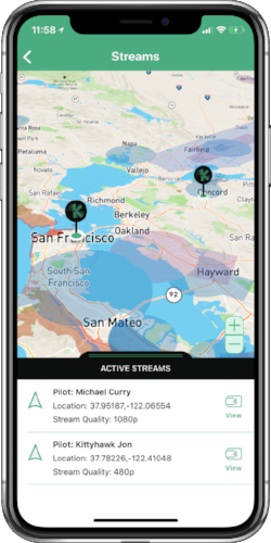
Multi-Channel Video Streaming Is Here
Since we’ve rolled out our secure video/audio streaming product, we’ve streamed thousands of hours, and gotten a ton of awesome feedback. We’re consistently impressed by the varied and exciting use cases that customers are using streams for. Everything from inspection, to law enforcement, to shot framing.
When we talked to our customers, we heard one request over and over again: more! So like a Zipline drone going to work in Rwanda: We bloody delivered. Starting today, Kittyhawk Enterprise customers can see who on their team is broadcasting a live stream, switch between streams like channels on your television, and even see which of their other team members are watching the stream in case they need to ask them questions.
We’ve got some more exciting features on the way, particularly for our customers that want to save their streams for later viewing. Did you hear that? It sounds like your collection of SD cards sobbing that they won’t get used anymore.
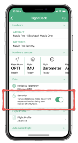
More Security, More Clarity
Helping your team make informed decisions about the data they collect and disseminate is critical towards keeping your organization in lockstep with your data policies. We’ve made it even easier for your team to understand what they’re sharing and who they’re sharing it with.
First, we’ve implemented DJI’s Local Data Mode into Flight Deck. Natively turn that on and off while still having the ability to upstream data into your Kittyhawk account.
Second, when it comes to flight telemetry, everybody is safer when it’s shared anonymously but we understand that there are situations where you don’t want to broadcast an active flight or are doing work in a sensitive area. Now, you can easily select the options for sharing your telemetry flight data with only your team, the public, or others, in one handy menu.
Introducing Kittyhawk Insights
“Nothing is more terrible than activity without insight.”
– Thomas Carlyle
We agree. There are far too many assumptions being made in the drone industry. We decided that we wanted to help people define what a “normal” flight looks like, and what some common-sense expectations should be. Kittyhawk Insights draws upon the power of all the data in the Kittyhawk platform to help understand safe operating procedures.

Here’s the introduction along with an FAQ to the series.
Here’s the first insight on Minimum GPS Satellites during a flight.
Kittyhawk Insights is a free public service to the drone industry to help everyone operate safer.
Until next time…
It’s been a really awesome start to 2018 and we look forward to bringing you more features that allow all of you to do even cooler stuff. Seeing the creative and innovative work being done with Kittyhawk is a continually humbling experience.
As always, if you feel like you’d like to be humbled by other people using your work, check out our careers page, particularly if you’re a front end aficionado.
Sincerely,
Jon Hegranes, Josh Ziering and the entire Kittyhawk team!


