Launching The Next Generation of Enterprise Compliance & Planning Solutions with Kittyhawk Dynamic Airspace™
Airspace used to be the airspace. Your map was my map. The sectional was everyone’s sectional. But today’s airspace is more nuanced, more granular, and more unique to the recurring tasks that drones are taking on in the enterprise.
As the operating system for enterprise drone programs, Kittyhawk’s job is to connect all the different data points and activities into a single system of record — trusted, encrypted, intuitive, and actionable. With the launch of Kittyhawk Dynamic Airspace™, we’re bringing a new level of compliance to drone operations while also giving our customers more control over THEIR airspace — and by definition — their workflows, their reports, and their risk tolerance.
While going through the LAANC approval process with the FAA last year, we started building our own airspace product with direct FAA data sources and UAS Facility Map content. But we didn’t just want to give you airspace — our goal is to give you YOUR airspace. Kittyhawk Dynamic Airspace enables your team to look at your airspace, see your authorizations, your locations, your annotations, and the points of interest relevant to your company.
We have combined our patent-pending airspace technology with Kittyhawk engineering and design to create an elegant and simplified airspace experience with colors, advisories, warnings, weather, and alerts that reduce noise and give a clear operational picture of your airspace. This is a foundational element that combined with our API will enable us to do things like send actionable compliance alerts — not if your people simply fly in controlled airspace, but if they fly in controlled airspace without proper authorization or operate outside of that authorization.
Once you put Dynamic Airspace into action across your drone program, each map layer will immediately add valuable situational awareness to your operation and for your team. Each map layer is a segment of your compliance whether you’re looking at controlled airspace or one of your LAANC authorizations. In addition to all of the critical airspace layers that you need for planning and flying safely in the national airspace (from special use airspace to UAS facility maps), you’ll find a whole host of new layers coming to YOUR maps.
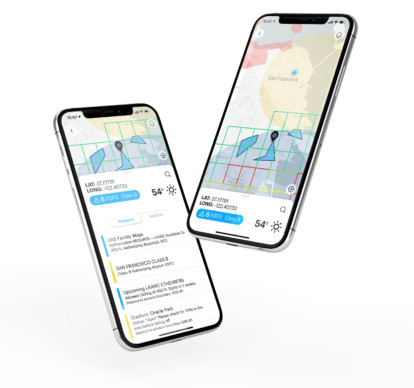
Straight out of the gate we’re introducing LAANC-as-a-Layer™ and you’ll be able to see current and upcoming authorizations on your map anywhere you’re accessing Kittyhawk including Android, iOS, and the new Kittyhawk web dashboard. Coming soon, we’ll be introducing a whole host of layers including COAs, waivers, missions, flights, and UTM data.
We’re not stopping there, and we’re already working on helping customers define areas of operation with details around buildings, facilities, and critical infrastructure to give their operation a new way to view their airspace when planning, flying, streaming, and reporting.
If you’re a Kittyhawk customer, talk to your Customer Success Representative about using Dynamic Airspace today. If you’re not yet a Kittyhawk customer, we’d love to talk to you about your drone program and how we can help you launch right, grow smart, and scale.


