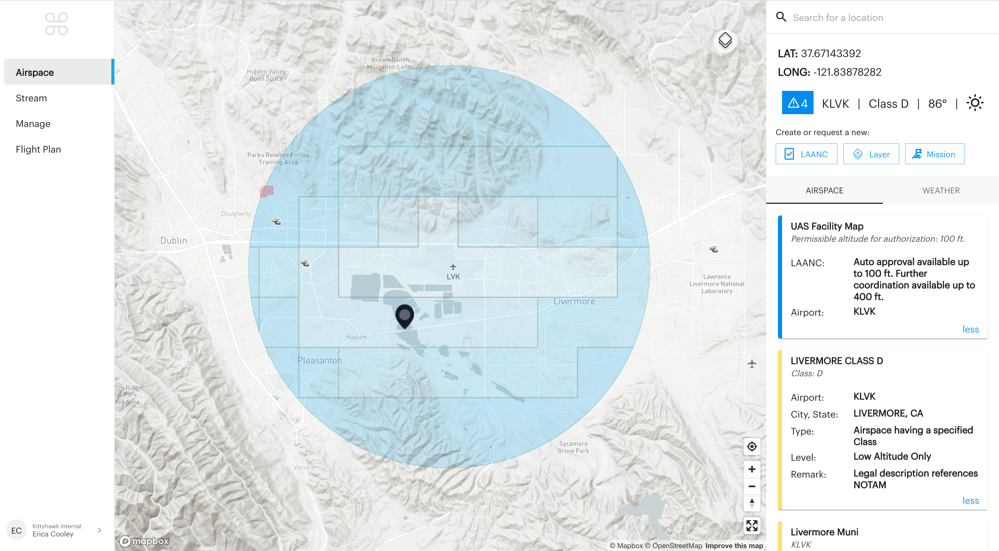
LAANC and UAS Facility Maps
The purpose of this blog post is to dive a little deeper into LAANC (Low Altitude Authorization and Notification Capability), the system to apply for and receive FAA authorization to operate in controlled airspace. Specifically, this post will go into more detail about UAS Facility Maps (commonly shortened to UASFMs) and the role they play in the LAANC system.
UAS Facility Maps (UASFMs)
LAANC is used to apply for and receive near-instant authorization to operate sUAS in controlled airspace in the United States. The idea behind LAANC is that even in busy controlled airspace, UAS can generally operate at or below certain altitudes without increasing the risk to other aircraft operating at the same air traffic facility or airport. UASFMs are the maps that depict those altitudes and provides some of the data used to facilitate LAANC authorizations.
Think about an airport with a single runway oriented East/West. Any airplane landing or taking off from that runway is going to be traveling east or west at low altitudes, as airplanes climb out after takeoff or descend to land. In this very common situation, UAS operations at higher altitudes to the east and west of the airport could pose a risk to low-flying aircraft, but operations to the north and south pose very little risk below the legal limit of 400 feet AGL because other aircraft rarely operate there. UAS Facility Maps reflect this relative risk, usually by limiting UAS to lower altitudes where other aircraft are more likely to operate and letting UAS operate up to 400 feet AGL in the portions of controlled airspace where there is less risk.
How UASFMs are Used in LAANC
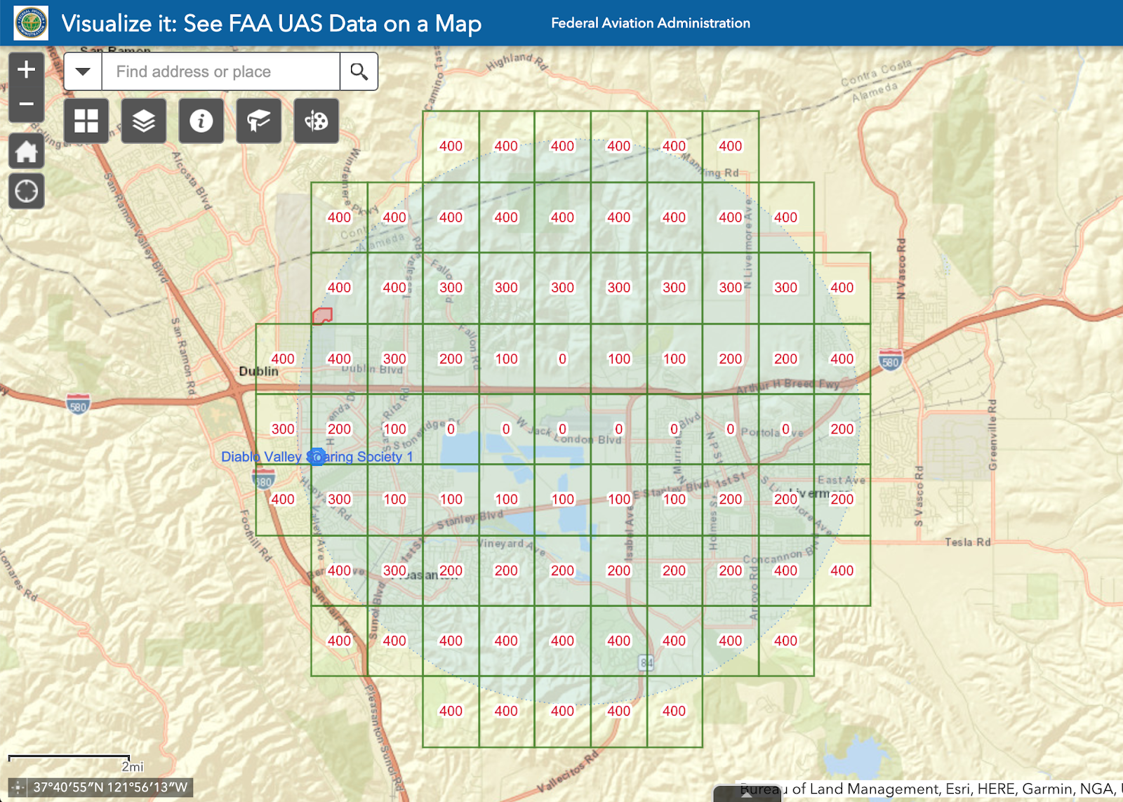
UAS Facility Maps are a main component of what makes LAANC operations possible. Each air traffic facility with controlled airspace that is LAANC-enabled is subdivided into small grids. Currently, those grids each represent a square, approximately one minute of latitude by one minute of longitude, each with a corresponding altitude. These altitudes are chosen by the local air traffic facility based on their knowledge of operations in that specific area. That altitude represents the height above the ground (AGL) where ATC and the FAA have deemed it generally safe to operate at or below that altitude, as long as you have permission from the FAA in the form of a valid LAANC authorization. If you submit a LAANC authorization request at or below the altitude for that UASFM grid, your operation should usually be approved instantly and automatically.
If for some reason you need to fly above that altitude you can still use LAANC for what are called “Further Coordination” requests. Further coordination means that the USS/FAA can’t approve your operation automatically based on the information you submitted (e.g. your request to operate above the UASFM grid altitude), but the responsible air traffic facility may be able to approve your authorization request anyway based on factors like how busy the airspace is, precisely when, where, and how long the operation will occur, etc.
Future development of the UAS Facility Maps are likely to be based on recommendations from industry, the FAA, users of LAANC and UASFMs, and groups who recommend policy to the FAA such as the Drone Advisory Committee (DAC). Recently, the DAC made two recommendations to the FAA about UASFMs: that each grid square be made smaller, to be 30 seconds of longitude by 30 seconds of latitude, and that the FAA could assign altitudes for these squares using algorithms that utilize multiple data sources.
Where can you find UASFM information?
The FAA provides an authoritative data source to the public for UAS-related data at the UAS Data Delivery System (UDDS) website. The UDDS website features “Visualize It”, which is a web-based map with important UAS data like National Security UAS Flight Restrictions (NSUFRs), and UAS Facility Maps. Kittyhawk and other LAANC USS use these data sources to populate our platform with authoritative data from the FAA. At Kittyhawk, we take that data and try to make it as easy to understand as possible for our user community.
If you want to learn more, the FAA has an entire subsection of their YouTube page devoted to UAS-related topics. One of these videos is all about how to navigate UAS facility maps, view this video below.


