What is the purpose of Aloft Geo Portal?
Since launching the crowdsourcing feature in 2020 on the B4UFLY platform, we have received thousands of submissions from everyone from concerned citizens to authoritative government agencies.
From government agencies sharing local ordinance data to individual operators sharing first hand experiences about take off and landing restrictions at a specific location, the Aloft team recognized all these submissions were aiming to achieve the same goal- to enhance the accuracy of the map for optimal safety of UAS and all operators in the NAS.
Who are the intended contributors for Geo Portal?
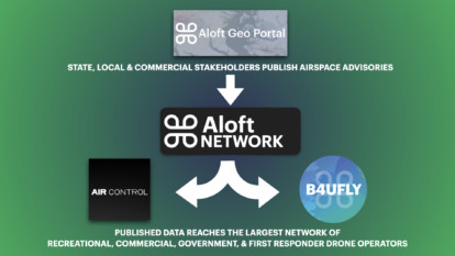
The intended users contributing data on Geo Portal are representatives from authoritative agencies like federal, state, and local government agencies, state and local municipalities, parks and recreations, public safety agencies, to name a few. Aloft Geo Portal was created as an easy to use tool to streamline sharing airspace data from authoritative agencies to users of the Aloft Network (including the B4UFLY platform).
To ensure the accuracy of each airspace advisory received through Geo Portal, your account must represent or otherwise be associated with an entity with official data about the ability to operate drones (including small recreational drones, commercial drones, drone delivery, or drone air taxis). This data could include information about drone restrictions, safety issues, or intended areas for flight (such as parks, drone corridors, etc).
Categories of entities that fit this authoritative requirement include, but are not limited to the following:
- Federal, state, and local government agencies
- Law enforcement and first responders
- Airport and heliport operators
- Commercial enterprises with public safety data (such as utilities)
If you are a representative from an authoritative agency once authenticated, you will be able to publish your agency’s airspace data directly through Geo Portal to the Aloft Network (including B4UFLY, Aloft and Aloft Air Control platforms).
Read the full Aloft Geo Protal Verification Policy here. If you have any questions about your organization or its status, please contact geo@aloft.ai.
Users from the following organizations are among some of the early contributors to the Aloft Geo Portal:


Do individual drone operators need to use Aloft Geo Portal?
Aloft Geo Portal was created to add new drone airspace mapping functionality to the Aloft Network (including B4UFLY). Aloft Geo Portal is the next evolution in our continual mission to improve the map accuracy and increase the safety of the NAS for UAS operators. For individual recreational and commercial drone pilots, no action is needed on Aloft Geo Portal.
This tool is intended to be used by local, state, and national authoritative agencies to add airspace advisory data for improving the accuracy of the B4UFLY and Aloft maps for the largest network of drone pilots in the nation. Individual operators do not need to create a new Aloft account to see the new advisories. Keep using Aloft and B4UFLY platforms as usual and the maps will be updated regularly.
If you are an individual operator or otherwise do not meet these verification requirements, we encourage you to continue using our crowdsourcing data tools by submitting or flagging data on the Aloft Drone Data Network. You can do this directly from the B4UFLY mobile apps and https://b4ufly.aloft.ai.
How to create an Aloft Geo Portal account, upload, manage & update advisories to the largest network of drone operators?
If you are a representative from an authoritative agency, navigate to https://geo.aloft.ai/sign-up and create a free account. To create trusted and reliable data, accounts must submit complete and accurate account information, including the following:
- Email addresses (that will be verified programmatically by submitting the correct activation code).
- Phone number
- First and last name
- Organization name
- Organization website (that corresponds to the activated email address)
If any of the above is missing, mismatched, or incorrect, the account will not be verified. The Aloft team may also reach out to the account owner with follow-up questions. Once your account has been authenticated, you can begin uploading, manage and update advisories on Geo Portal.
Watch our recent webinar on-demand for a step by step demo of how to use Aloft Geo Portal to start sharing airspace advisories today.
*To note, currently, we are processing and publishing airspace advisories daily, so it is advised to publish advisories to Aloft Geo Portal the day before you’d like them to go live.


