Understanding what controlled airspace looks like on the B4UFLY map and the steps needed to gain access to fly a drone in controlled airspace.
Last week, the FAA “Drone Guy”, Kevin Morris joined our Head of Community, Erica Cooley to kick off our summer webinar series, The ABCs of National Airspace Types. This three part webinar series focuses on providing educational and safety information pertaining to UAS operations near/or in the specific airspace types in the NAS and how to identify them on the B4UFLY platform. In our July webinar, we discussed controlled airspaces, including Class Bravo, Charlie, Delta, & Echo 2 airspace and uncontrolled airspace, Class Golf.
Continue reading for an explanation of each of the different types of controlled airspace pertaining to drone operations. Watch the entire webinar discussing each of the below airspaces types as well as an audience Q&A and demo of how to submit a LAANC authorization on the Aloft app on-demand here.
Identifying Different Types of Airspace in the NAS
The chart above depicts how we divide up airspace in the United States. It looks complicated but what it really boils down to is controlled versus uncontrolled airspace. Controlled airspace includes Class Bravo, Charlie, Delta, & Echo 2 airspace. Class G is uncontrolled airspace. Prior to flight, the most important thing for drone pilots to remember is to check either B4UFLY or any of the FAA’s UAS Service Supplier provider apps to see if their planned operation is in controlled or uncontrolled airspace. If it’s in controlled airspace, you’ll need approval from the FAA to fly, prior to flight. This is called an airspace authorization. While most can be requested and granted through LAANC, some airspace authorization requests must still go through the FAA’s Drone Zone.
If your flight is in uncontrolled airspace – you do not need to receive FAA authorization to operate in it. However, you DO have to ensure that you fly below 400 feet which is the maximum altitude at which you can fly in uncontrolled airspace.
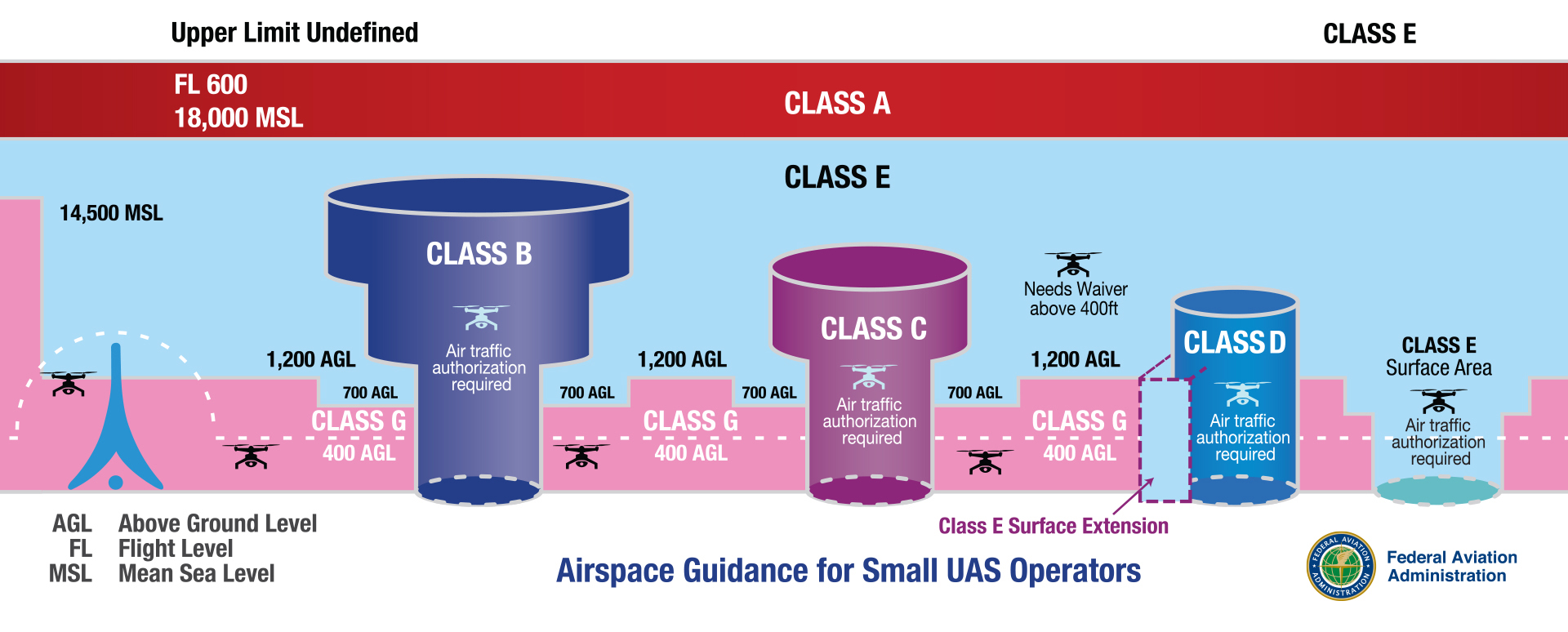
Identifying Different Types of Airspace in the NAS by Color
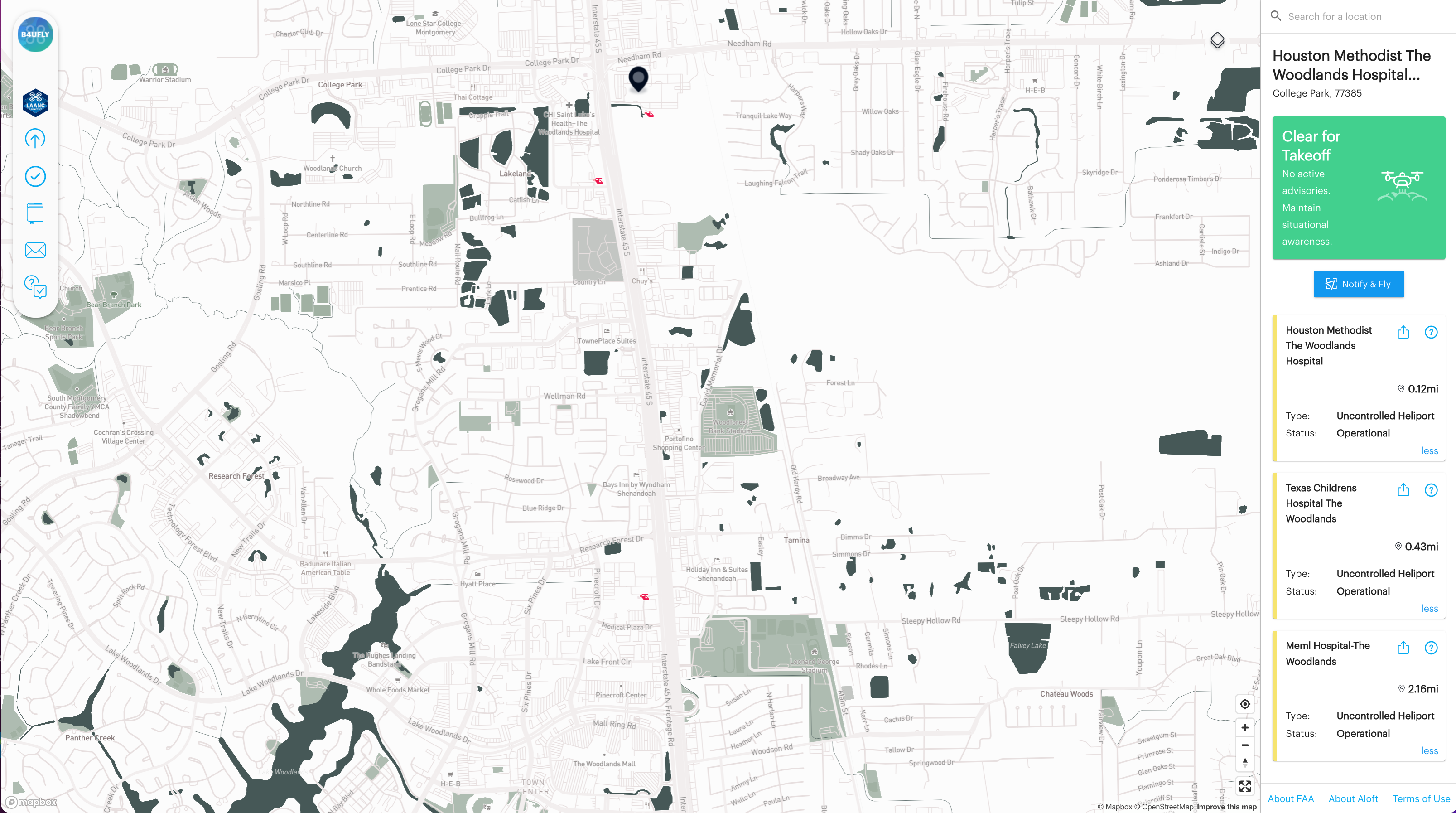
No Color = Class G uncontrolled airspace
When viewing the location where you want to fly on the B4UFLY app, or Aloft LAANC app, airspace that is not shaded, indicates uncontrolled (or Class G) airspace. The airplane and helicopter icons indicate airports, seaplane bases or helipads in controlled and uncontrolled airspace. Drone operations in uncontrolled airspace are permitted without an FAA airspace authorization up to 400 feet AGL. A gray airplane or red helicopter icon that is not surrounded by a shaded color circle indicates a public airport, helipad, or seaplane base in uncontrolled airspace. You can see three Class G heliports in the Houston, Texas area below.
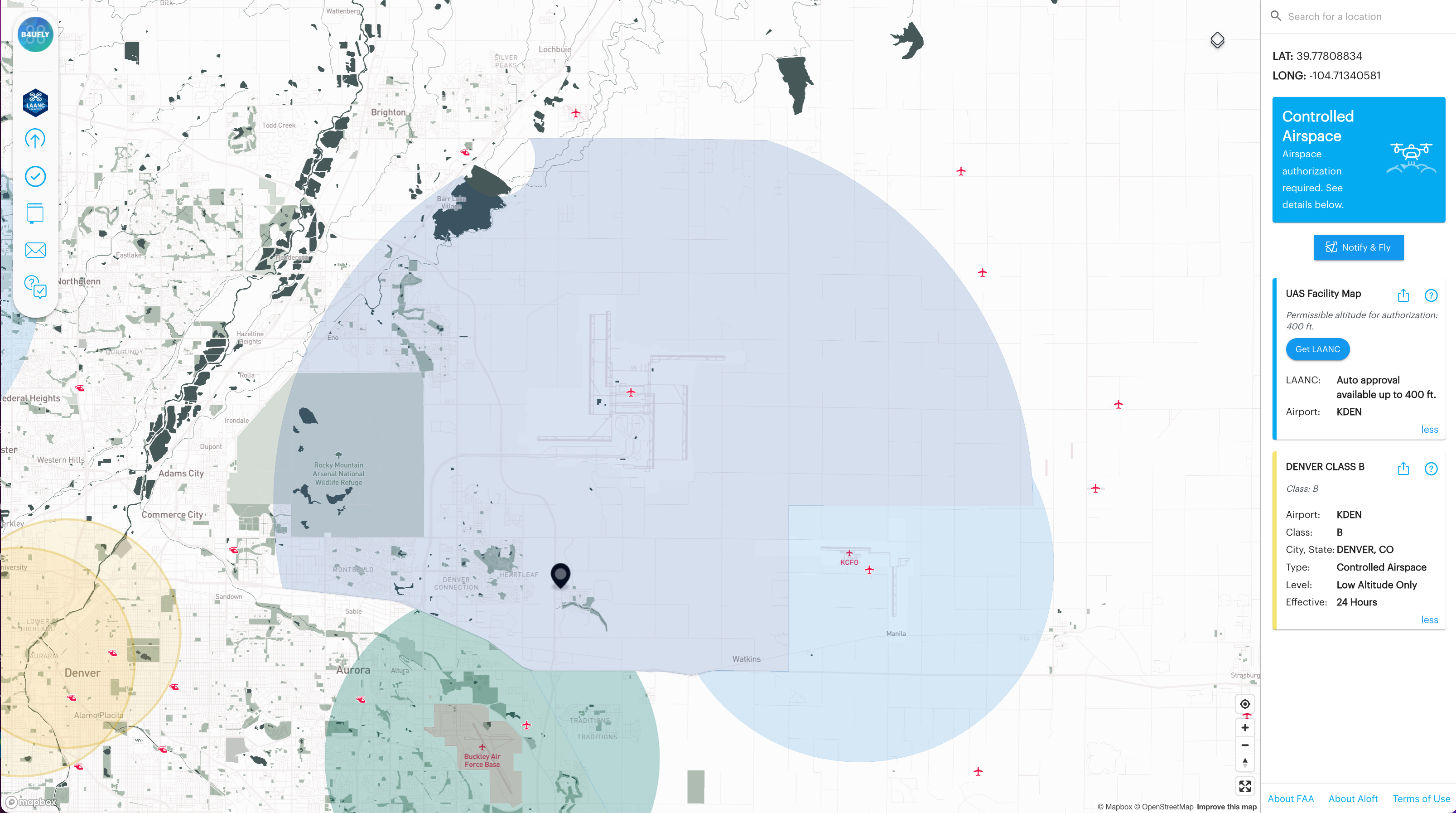
Dark Blue = Class B controlled airspace
Class B airspace is airspace that surrounds our nation’s busiest airports. One example of Class B airspace is in Denver, Colorado. Denver International Airport’s Class B airspace is depicted by a dark blue shaded area. To operate a drone anywhere within this airspace, you will need an FAA authorization prior to flight and may be limited to altitudes less than 400ft AGL. In this example you can use LAANC to request your authorization, which means you can apply through Aloft or any of the FAA’s Approved UAS Service Suppliers of LAANC.
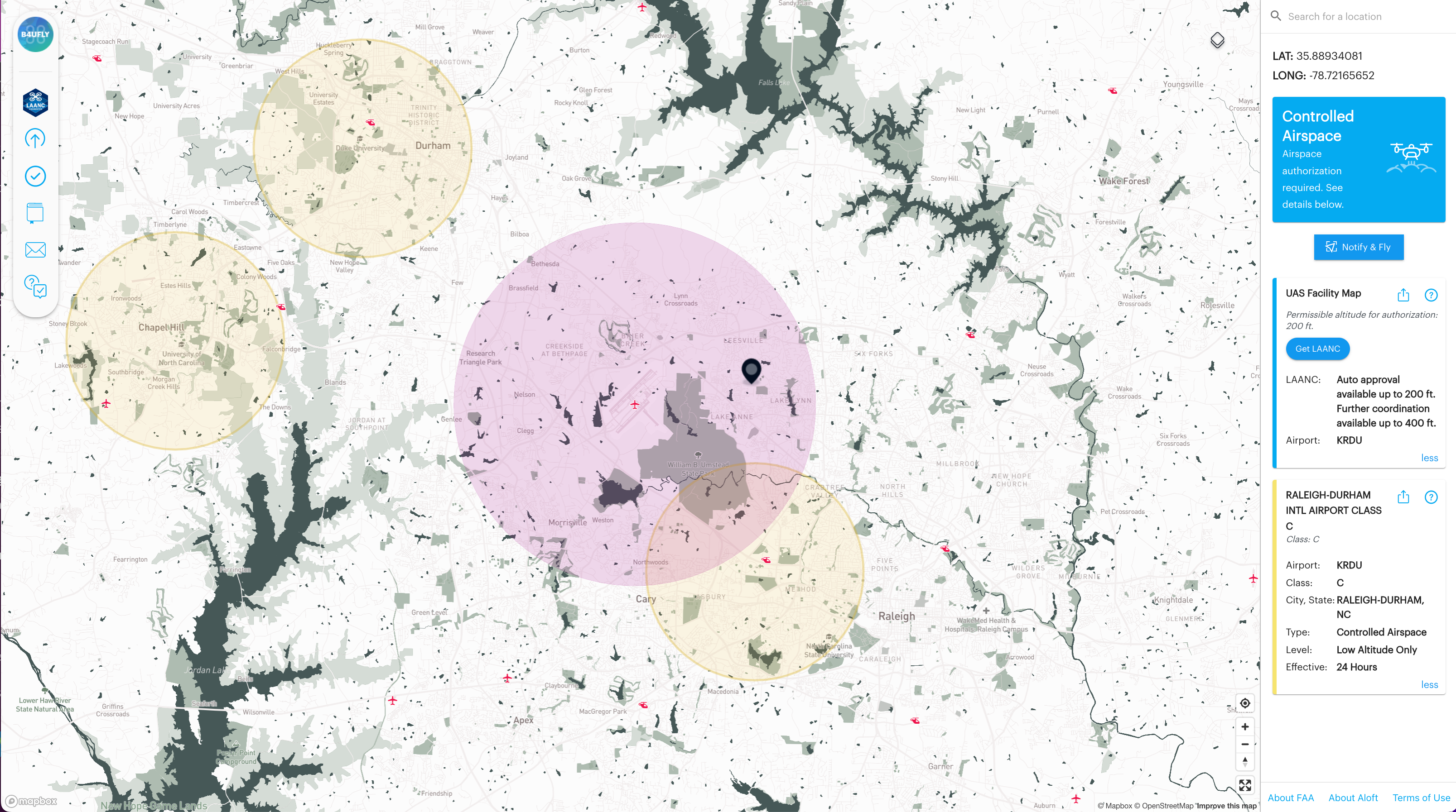
Purple = Class C controlled airspace
Class C airspace generally surrounds those airports that have a control tower, are serviced by a radar approach control, but are not quite as busy as Class B airports. The airspace is usually circular in shape and extends out to a 5-mile radius from the airport center. Raleigh-Durham International is an airport located in Class C airspace. This is indicated on the map by the purple shaded circle surrounding the airport. To operate a drone anywhere in this airspace, you will need an FAA airspace authorization and may be limited to altitudes less than 400ft AGL.
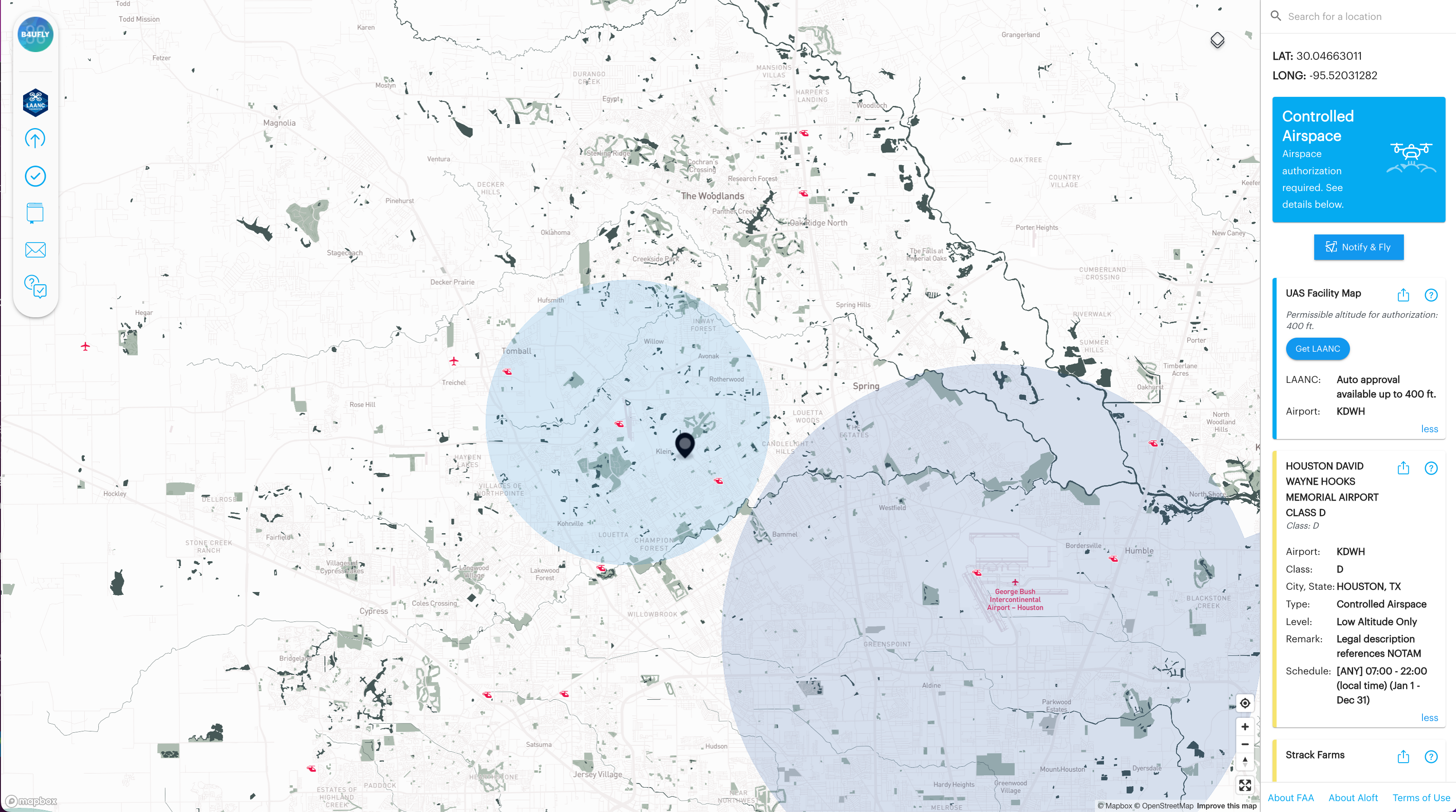
Light Blue = Class D controlled airspace
Class D airspace generally surrounds those airports that have a control tower but are not as busy as Class B or C airports. The airspace is usually circular in shape and extends out to a 5-mile radius from the airport center. Houston’s David Wayne Hooks Memorial Airport is an airport located in Class D airspace. This is indicated on the map by the light blue shaded circle surrounding the airport. To operate a drone anywhere in this airspace, you will need an FAA airspace authorization and may be limited to altitudes less than 400ft AGL.
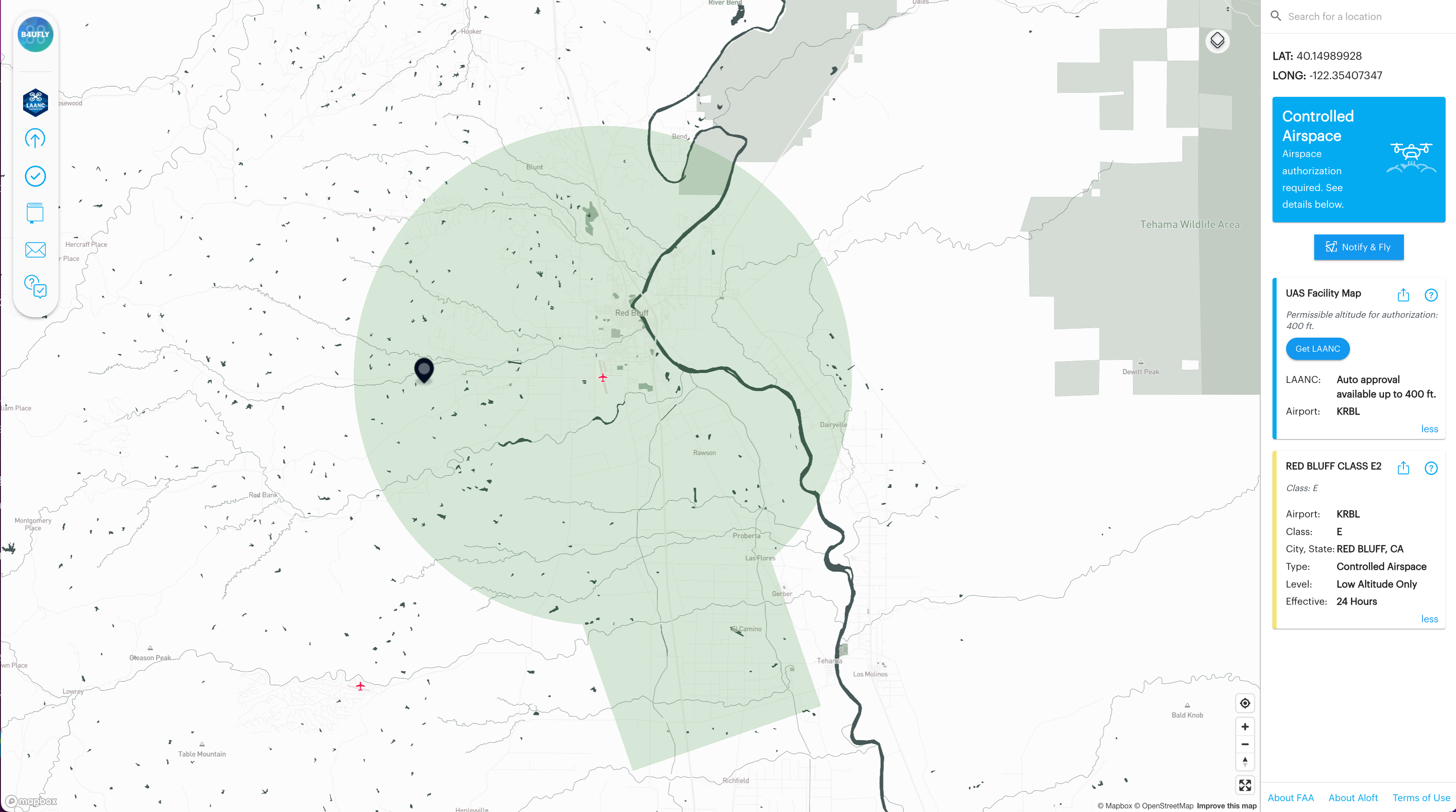
Green= Class E2 controlled airspace
Airports that do not have operating control towers may be located within Class E airspace. Surface Class E airspace designated for an airport is known as Class E2 airspace. Drones operators planning to fly in Class E2 airspace must make sure they have authorization from the FAA prior to flight and you may be limited to less than 400ft AGL. Red Bluff Airport is an airport located in Class E2 airspace as indicated on the map by the green shaded area surrounding the airport in a 5-mile radius. You’ll notice that Class E2 airspace can have interesting shapes. This is to help protect traditional aircraft landing at the airport during poor weather.
We hope you found this information about uncontrolled airspace (Class G) and controlled airspaces, Class B, C,D, E2 helpful in understanding operational airspace for drone operations. To learn more about operations near small airports in Class G uncontrolled airspace click here. For a full presentation on the topics covered in this blog including an audience Q&A and demo of how to apply for a LAANC authorization on the Aloft app to gain access to controlled airspace surrounding 731 airports around the country, watch the webinar on-demand above. Or listen to just the audience Q&A portion of the webinar on this week’s episode of Aloft’s B4UFLY Check the Map podcast below.
If you are interested in learning more about the different types of special use airspaces in the NAS including stadium/ presidential TFRs, local layers, SFRAs, MOAs, how these types of airspace may impact drone operations, and how to identify each on the B4UFLY map by color, watch Aloft Head of Community, Erica Cooley and FAA “Drone Guy”, Kevin Morris on B4UFLY Check the Map: The ABCs of National Airspace Types Webinars: Part 2- Special Use Airspaces: Stadiums, Local Layers, MOAs below.


