Understanding what special use airspace looks like on the B4UFLY map and understanding whether you are permitted to operate a drone at your desired location.
Last week, the FAA “Drone Guy”, Kevin Morris joined our Head of Community, Erica Cooley for Part 2 of our series, The ABCs of National Airspace Types. This three part webinar series focuses on providing educational and safety information pertaining to UAS operations near/or in the specific airspace types in the NAS and how to identify them on the B4UFLY platform. In our October webinar, we discussed special use airspaces like like Stadium and Presidential TFRs, SFRAs, MOAs, and more.
Continue reading for an explanation of each of the different types of special use airspace pertaining to drone operations. Watch the entire webinar discussing each of the below airspaces types as well as an audience Q&A on-demand here.
Identifying Different Types of Special Use Airspace in the NAS
Airspaces colored yellow on the map will also be colored yellow in the airspace advisory bar on the right (desktop) or below (mobile). This indicates that drones may be allowed in this airspace but to first check the airspace advisory bar for further detail and to use caution during operations in this airspace. As seen in the screenshot below of the B4UFLY map showing Michigan International Speedway in yellow with the an airspace advisory stating that flights over stadiums during major league baseball, National Football League, NCAA, and motor speedway events are prohibited. So always check for any active TFRs in the area surrounding major sporting stadium and centers before take off.
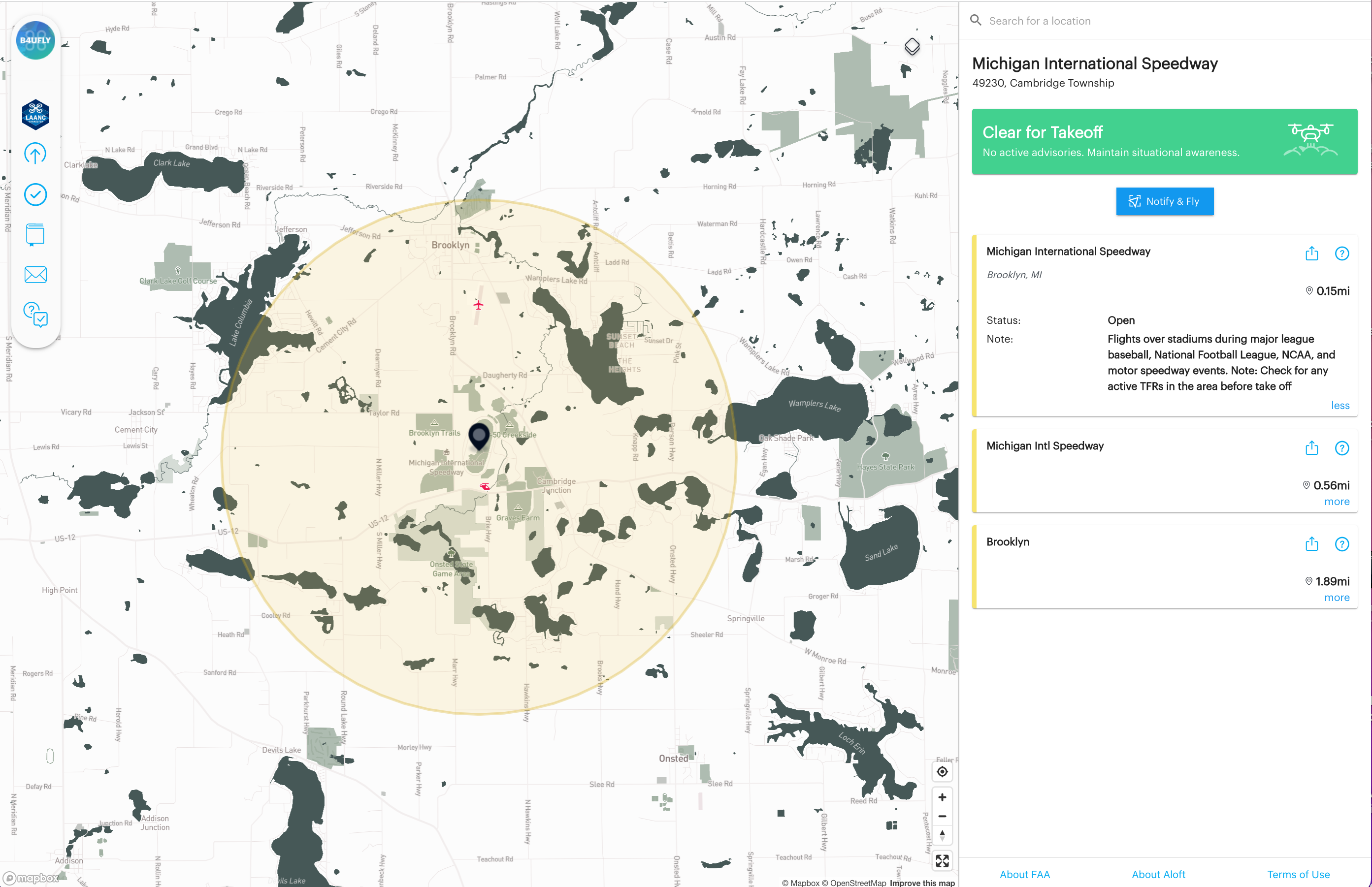
Stadiums TFRs = Yellow
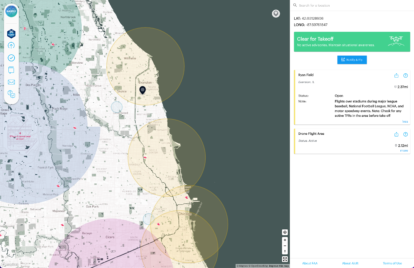
The FAA manages our nation’s airspace to keep it safe for everyone. Sometimes safety or security events require restricting access to the airspace for a specific period of time. This is called a Temporary Flight Restriction (TFR). Some of the most common TFRs are around major sporting events. For example, in the screenshot below, in the Chicago, Illinois area there are three yellow circles on the map surrounding Ryan Field, Wrigley Field, and Soldier Field. If major sporting events are taking place at these locations then drone operations are prohibited. If you’re planning to fly in an area that is near a stadium, always check for TFRs before takeoff.
VIP Movement (Presidential) TFRs = Yellow
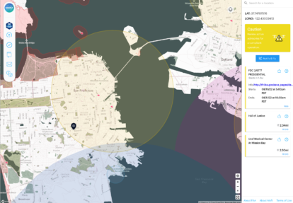
Another common TFR that prohibits drone flying is “VIP Movement”, often called “Presidential TFRs”. Drones are prohibited from flying when the president or anyone else with a VIP designation is in the area. Below is an example of an active presidential TFR in the San Francisco area on the B4UFLY map. As you can see the flight status bar at the top of the advisory panel changes from green ‘Clear to Take off’ to yellow ‘Caution: Review the active advisories for a compliant operation’ indicating that if your intended operation takes place in a location contained within the yellow circle on the map within the timeframe outlined in the presidential TFR advisory, your drone operations are prohibited. This is why planning ahead and checking your operational area on the B4UFLY or Air Control platform as far in advance is beneficial to gain important situational awareness information ahead of time. But also to note, checking the map again close to your intended start time of your operations is recommended to ensure no new airsapce advisory information has been added since you last checked. Double checking the map prior to take off is a great pre-flight checklist safety practice.
Local Layers = Yellow
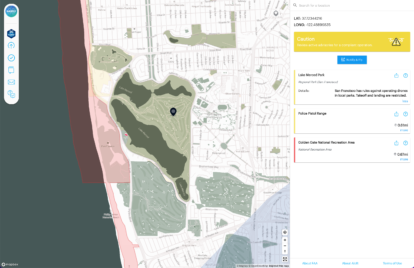
Local ordinances and rules such as drone restrictions for parks and recreational areas are identified in yellow on the map. Lake Merced Park in San Francisco, in the screenshot below, is an example of a local advisory you may see on the map. Under ‘Notes’ for this advisory, you can see that San Francisco prohibits the operation of drones in all local parks.
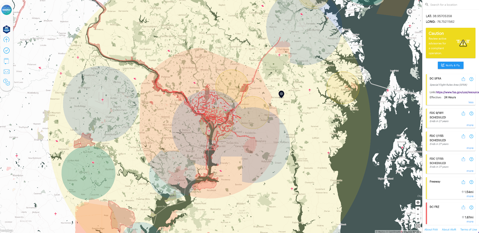
Special Flight Rules Area (SFRA) = Yellow
Certain areas may have ongoing flight restrictions. The National Capital Region is governed by a Special Flight Rules Area (SFRA). The SFRA covers a 30-mile radius around Ronald Reagan Washington National Airport, which restricts all flights in the greater DC area.
The SFRA is divided into a 15-mile radius inner ring and a 30-mile radius outer ring.
The airspace around Washington, D.C. is more restricted than in any other part of the country. It is considered “national defense airspace” and all aircraft operations requires FAA and Transportation Security Administration authorization. Violators face stiff fines and criminal penalties.
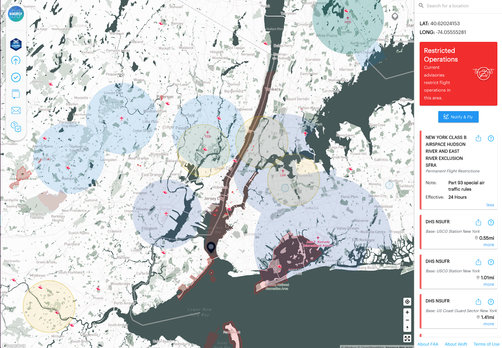
Permanent Flight Restrictions Special Flight Rules Area (SFRA) = Red
Another example of a SFRA is in New York. The Hudson and East River are a Special Flight Rules area due to the high volume of low flying aircraft up and down the river. Just like Washington DC, this is a No Drone Zone. In the screenshot of the B4UFLY map below, you can see the area over the Hudson and East River is shaded red indicating this area has a permanent flight restriction under Part 93 special air traffic rules. These are just a few examples of Special Flight Rules Areas (SFRA) in the national airspace system. That is why it is important to always check the B4UFLY app before take off to check for any airspace advisories which may impact the area you intend to operate your drone in.
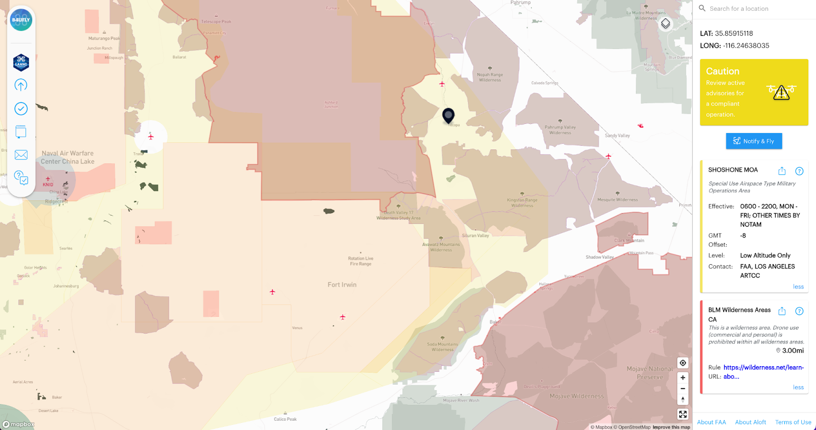
Special Use Airspace- Type: Military Operation Areas (MOA) = Yellow
Military Operation Areas or MOAs consist of airspace with defined vertical and lateral limits established that separate military activities from other aircraft traffic. In the screenshot below, the Shoshone Military Operations Area is yellow. If you operate a drone in this area exercise extreme caution as military activity could be conducted anytime between 6 am and 10 pm, Monday through Friday or during other times by NOTAMs.
We hope you found this information about special use airspaces helpful in understanding operational airspace for drone operations. For a full presentation on the topics covered in this blog including an audience Q&A, watch the webinar on-demand above. Or listen to just the audience Q&A portion of the webinar on Aloft’s B4UFLY Check the Map podcast below.


