Understanding what the different types of restricted airspaces look like on the B4UFLY map.
This week, FAA Air Traffic Control Specialist, Sebastian Yanguas joined our Head of Community, Erica Cooley for Part 3 of our series, The ABCs of National Airspace Types. This three part webinar series focuses on providing educational and safety information pertaining to UAS operations near/or in the specific airspace types in the NAS and how to identify them on the B4UFLY platform. In our December webinar, we discussed restricted airspaces like critical infrastructure DOD/ DOE/DOI NSUFRs, TFRs, national parks/memorials/preserves, and more.
Continue reading for an explanation of each of the different types of restricted airspace pertaining to drone operations. Watch the entire webinar discussing each of the below airspaces types as well as an audience Q&A on-demand here.
Identifying Different Types of Restricted Airspace in the NAS
A restricted area is airspace designated under 14 CFR part 73 provisions, within which the flight of aircraft, while not wholly prohibited, is subject to restriction. Restricted areas are designated when determined necessary to confine or segregate activities considered hazardous to nonparticipating aircraft. Restricted areas denote the existence of hazards to aircraft such as artillery firing, aerial gunnery, or guided missiles.
Restricted airspaces are colored red on the map and will also be colored red in the airspace advisory bar on the right (desktop) or below (mobile). This indicates that drones are restricted in this airspace due to current restriction advisories like DOD/DOE/DOI NSUFR, National parks, active TFRs/ NOTAMs, etc.
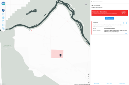
National Security UAS Flight Restrictions (NSUFRs) for Critical Infrastructure = Red
Drones are prohibited from flying over designated national security sensitive facilities. National Security UAS Flight Restrictions (NSUFRs) cover sensitive security locations, usually belonging to the Department of Energy (DOE) or Department of Defense (DOD). Operations are prohibited from the ground up to 400 feet above ground level, and apply to all types and purposes of UAS flight operations. Certain critical infrastructure, such as nuclear power plants are restricted for drone operations. Below is screenshot of an example of a DOE NSUFR for Hanford Nuclear Plant in Yakima, WA.
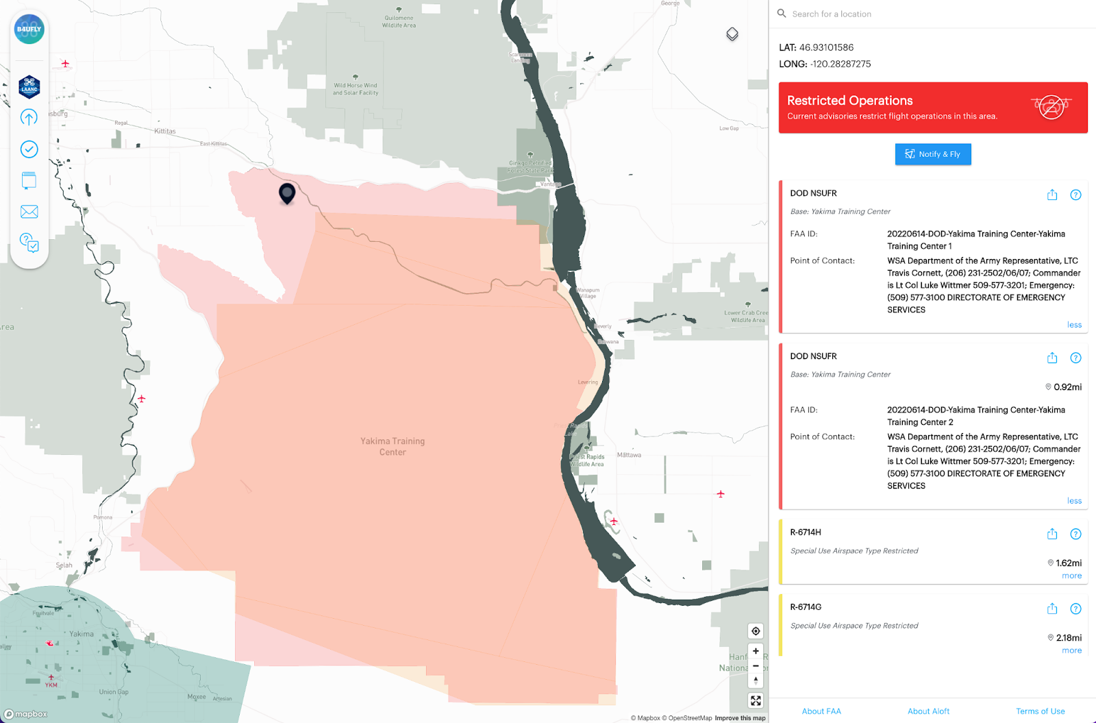
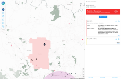
National Security UAS Flight Restrictions (NSUFRs) for Department of Defense Facilities = Red
Another type of NSUFR applies for military bases designated as Department of Defense facilities. Below is a screenshot of the DOD NSUFR surrounding Camp Bullis DOD-Joint Base in San Antonio, TX. This is a DOD facility making drone operations anywhere in the area seen in red on the map prohibited.
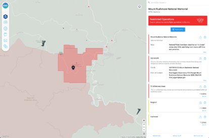
National Security UAS Flight Restrictions (NSUFRs) for National Landmarks = Red
The final type of NSUFR is for National landmarks like Statue of Liberty, Hoover Dam, and Mt. Rushmore. Below is a screenshot of the DOI NSUFR surrounding Mt. Rushmore. As you can see, Mt. Rushmore falls under the Department of Interior NSUFR restricting drones from operating anywhere in the red area surrounding the monument.
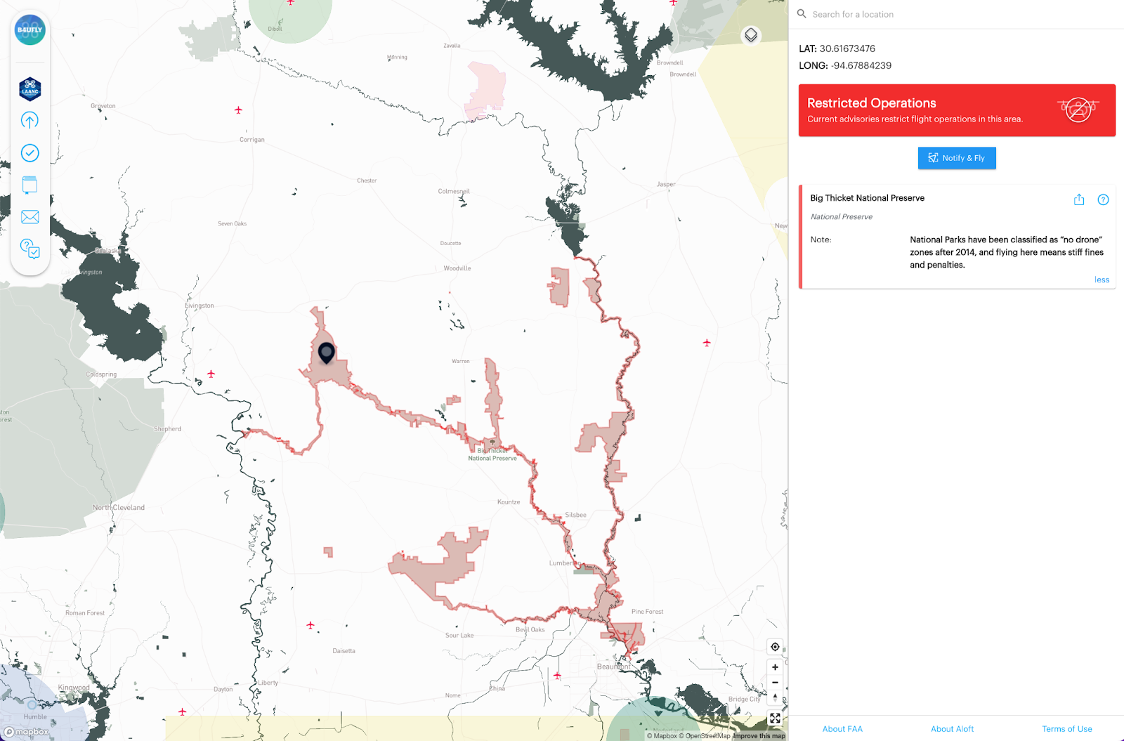
National Parks, Memorials, Wilderness Areas, Preserves = Red
National Parks have been classified as “no drone” zones after 2014, and flying here means stiff fines and penalties. In general, take off and landing of a UAS is prohibited in lands administered by the National Parks Service and in Wilderness areas administered by a variety of federal agencies such as the Forest Service and Bureau of Land Management. Drones are allowed in some National Forests and in some BLM lands that aren’t designated as wilderness. Watch past webinar on-demand and read blog about drone operations in local, state and national parks here.
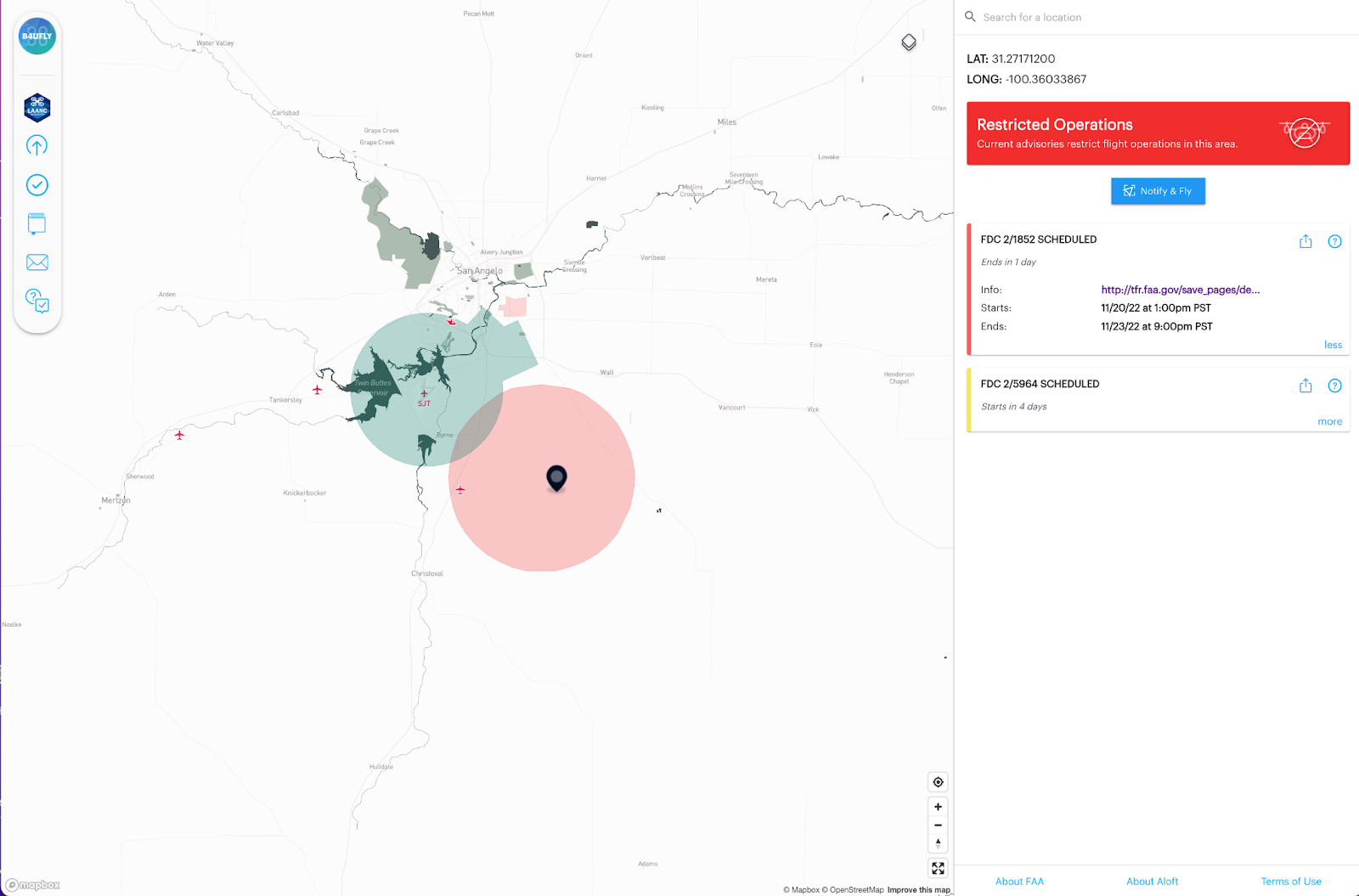
Temporary Flight Restrictions (TFRs) = Red
Temporary Flight Restrictions (TFRs) define a certain area of airspace where air travel is limited because of:
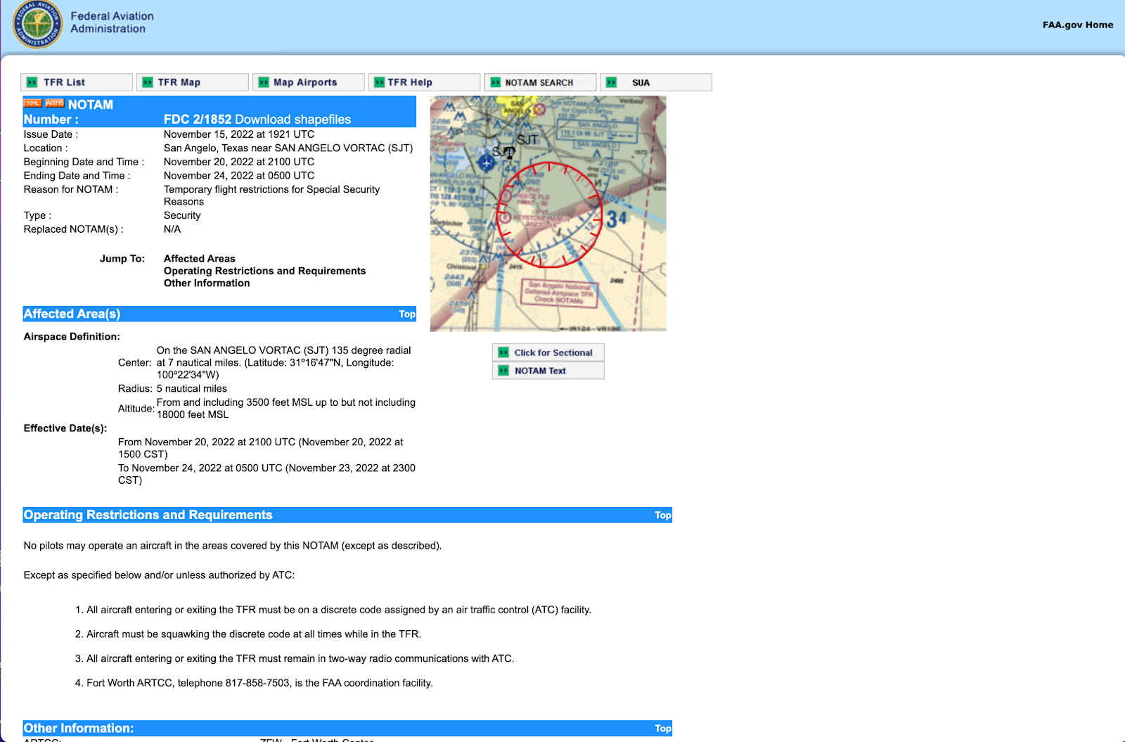
On the advisory card for the TFR, click the info link text to read the text of the actual TFR containing the details about the restriction, including the size, altitude, and time period of the TFR, and what types of operations are restricted and permitted. In this screenshot is a special security TFR in the San Angelo, TX area.
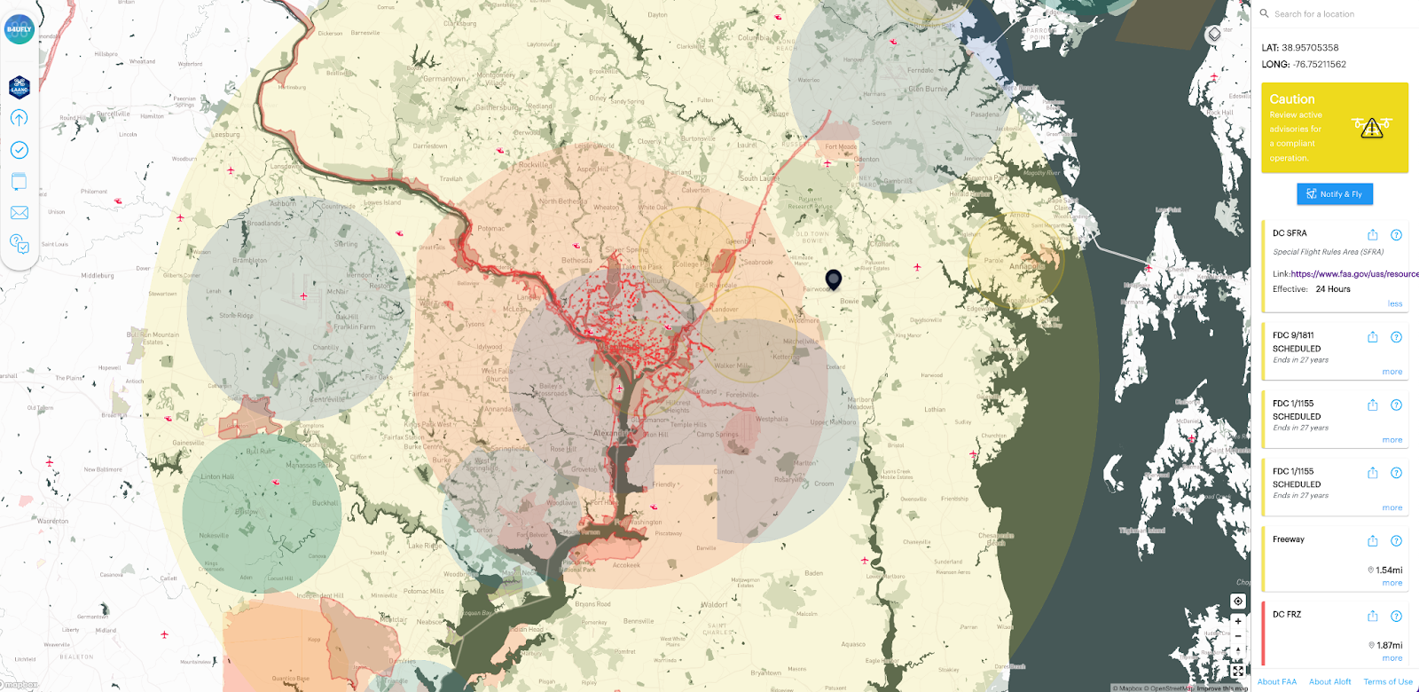
Permanent Special Flight Rules Area (SFRA) = Red
Certain areas may have ongoing flight restrictions. The National Capital Region is governed by a Special Flight Rules Area (SFRA). The SFRA covers a 30-mile radius around Ronald Reagan Washington National Airport, which restricts all flights in the greater DC area.
The SFRA is divided into a 15-mile radius inner ring and a 30-mile radius outer ring.
The airspace around Washington, D.C. is more restricted than in any other part of the country. It is considered “national defense airspace” and all aircraft operations requires FAA and Transportation Security Administration authorization. Violators face stiff fines and criminal penalties.
We hope you found this information about restricted airspaces helpful in understanding operational airspace for drone operations. For a full presentation on the topics covered in this blog including an audience Q&A, watch the webinar on-demand above. Or listen to just the audience Q&A portion of the webinar on Aloft’s B4UFLY Check the Map podcast below.


