As we approach summer and weather conditions continue to improve, many drone operators may be wanting to take their drones with them to explore the many natural beauties to be found in parks across the U.S. Before heading out to your park of choice with your drone, read the following information on the rules and regulations for drone operations in national,state and local parks as well as examples of how these different types of parks appear on the B4UFLY app. We encourage you to always check the B4UFLY app for airspace advisories in your designated operational area to ensure safety and compliance for your intended UAS operation.
As part of the B4UFLY Check the Map educational webinar and podcast series, we recently hosted a discussion with Rebekah Waters, Senior Communications Specialist at the FAA’s UAS Integrations Office to provide further clarity on rules and regulations on drone operations in national, state, and local parks. Watch and/or listen to the webinar and podcast on-demand below.
National Parks Service (NPS) Rules Against Drone Operations on Federal Land
In general, take off and landing of a UAS is prohibited in lands administered by the National Parks Service and in Wilderness areas administered by a variety of federal agencies such as the Forest Service and Bureau of Land Management. Drones are allowed in some National Forests and in some BLM lands that aren’t designated as wilderness. Prohibitions on drones at the state and local level vary depending on the state, park system, or city/county, and can be different from park to park in the same system. Read more about drone operations in state and city parks below.
The NPS issued Policy Memorandum 14-05, on June 19, 2014. It was issued as interim policy, but it is still in force with very few exceptions according to the NPS webpage. This policy prohibits launching, landing, and operation of uncrewed aircraft on lands and waters administered by NPS, including National Parks, National Monuments, National Recreation Areas, National Historic Sites, National Seashores, National Memorials, and others. These sites are shown in the Aloft app and B4UFLY app as locations where drone flights are clearly prohibited.
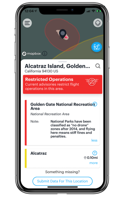
For example, view the screenshot of Alcatraz Island in San Francisco Bay on the B4UFLY map. Alcatraz Island is part of the Golden Gate National Recreation Area and is administered by the National Parks Service. B4UFLY shows these areas in red, including Alcatraz and the area surrounding the Golden Gate Bridge.
The official National Park Service website has a page dedicated to “Unmanned Aircraft in the National Parks”, where it addresses some of the reasons why the NPS restricts the use of UAS in National Parks, how to obtain a permit, FAQs, and penalties for noncompliance.
Some drone operators have tried to get around these regulations by taking off from private property and flying over NPS lands and waters. Even if you do not launch, land, or operate from NPS-administered lands and waters, the NPS could apply regulations about wildlife disturbance, nuisance or disorderly conduct, or operating a motor vehicle to your drone flight regardless of where you launch and land. In addition to any posted regulations, you still must follow all FAA regulations for UAS operations, such as keeping your drone within visual line of sight.
Drone Operations in National Forests and Wilderness Areas
Flying a drone in National Forests is not outright prohibited. The US Forest Service allows drones subject to a variety of restrictions, including following all regular FAA regulations and guidance, staying away from wildlife, designated wilderness areas, firefighting operations, manned aircraft operations, and any TFRs. Flying a drone is prohibited in designated Wilderness areas including wilderness areas in National Forest land. The National Wilderness Preservation System is a network of over 111 million acres – more area than the state of California – of public land comprising more than 760 wilderness areas administered for the American people by the federal government.
The Wilderness Act of 1964 says that in wilderness areas there “shall be no use of motor vehicles, motorized equipment…no landing of aircraft, no other form of mechanical transport…”In practical terms, the US Forest Service considers UAS to be “mechanized” equipment and prohibits taking off or landing in congressionally designated Wilderness areas on National Forest Service Lands.
To learn more about wilderness areas, including an interactive map of Wilderness areas, you can visit Wilderness Connect. This resource depicts designated Wilderness areas from multiple federal agencies administering federal lands across the country.
Common Limitations on sUAS in State and City Parks
A complicating factor in determining whether or not you can fly sUAS from parks is that the rules vary from state to state and even park to park. Many states allow UAVs to operate in their state parks with limitations and/or permits, but the information can be difficult to find or challenging to apply.
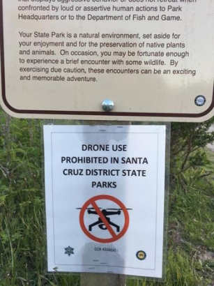
California and Washington State are good examples of states that have commonly found limitations on sUAS operations in their parks. On their websites, both California and Washington State generally allow RC aircraft or UAS to operate in their state parks. In practice, due to many restrictions and requirements, and the power granted to local park management, it is either not allowed or not easy to operate UAS in these parks.
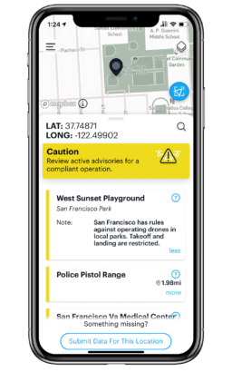 A good example of this is the City of San Francisco in California has rules against operating drones in local parks. Meaning take off and landing of a UAS in any San Francisco park is restricted. Here you can view a screenshot from the B4UFLY app reflecting these restrictions in a local park in the San Francisco area. Aloft continues to engage additional cities, states, and countries to include their data in the B4UFLY app to improve the world’s authoritative database for safe and compliant drone flight.
If you’re thinking of flying at a state or city park, the best place to start is usually the website of the parks system. When available, this often has the most recent and relevant information, and is the most accessible. You should attempt to find out what type of park it is and what activities are allowed, and seek out any specific information about flying sUAS. This is also where you’re likely to find contact information to call or email to ask questions or to seek the appropriate permits or permission if required.
If you are already at the park, the best place to look for information is near any posted orders, such as those regarding park safety, fires, other activities, maps, and other information. These are frequently located at trailheads or parking lots near parks. Remember, all FAA UAS rules still apply for recreational operations and commercial operations.
Lastly, keep in mind that parks regulating UAS may have good reasons for doing so, including protecting wildlife, lowering the risk of fires, or to limiting risk from UAS operating near people or other recreational activities.
One complicating factor for commercial operations is that many state parks have rules that require a permit for any commercial operation (and sometimes recreational). Additionally, many state parks systems use a similarly broad interpretation of the word ”commercial” that the FAA uses. A good rule of thumb is that if the FAA would consider an operation as a Part 107 operation, the state park probably will as well.
Many state parks systems require permits for any commercial UAS operations occurring on their property. Since it is particularly important that commercial operations operate compliantly, it is important to fully understand and comply with regulations requiring permits. Also, the permit process may be slow, so it is best to plan ahead and communicate with the authorities at the park where you plan to operate.
Continually Improving the Accuracy of Airspace Advisories
Here at Aloft, we are constantly striving to improve the accuracy of airspace advisories on the map to provide the best situational awareness for all operating in the National Airspace System. One way our user community can help is by sharing specific areas where increased situational awareness is needed. If you represent a government agency, a public safety agency, or other industry stakeholder, share data on the B4UFLY app through our crowdsourcing feature. If you are an sUAS operator, use the Notify & Fly feature on the B4UFLY app to share your operation area when operating in uncontrolled airspace to increase situational awareness for your designated airspace. Watch these tutorial videos to learn more about how to share data and a Notify & Fly on the B4UFLY app. Feel free to reach out with questions at b4ufly@aloft.ai.


