Understanding the FAA’s rules on drone operations near small airports in uncontrolled airspace.
Watch this video to learn more about airspace advisories for small airports in uncontrolled airspace on the B4UFLY platform.
Since the release of the update to the B4UFLY app at the end of 2020 enabling the new crowdsourcing feature, we’ve had a great response from concerned citizens, recreational flyers, and commercial UAS pilots submitting airspace advisory data around the country. Daily we have been receiving many submissions reporting intent to fly recreationally and commercially near small airports. To date, nearly 10% of all data submissions have been inquiries about operating drones near small airports. This data clearly communicates that drone operators are seeking clarity about operating sUAS near and around small airports in uncontrolled airspace. Below learn more about how the FAA designates these airspaces and what actions you should take to fly safely and compliantly.
Tips for Flying Your Drone Near Small Airports in Uncontrolled Airspace
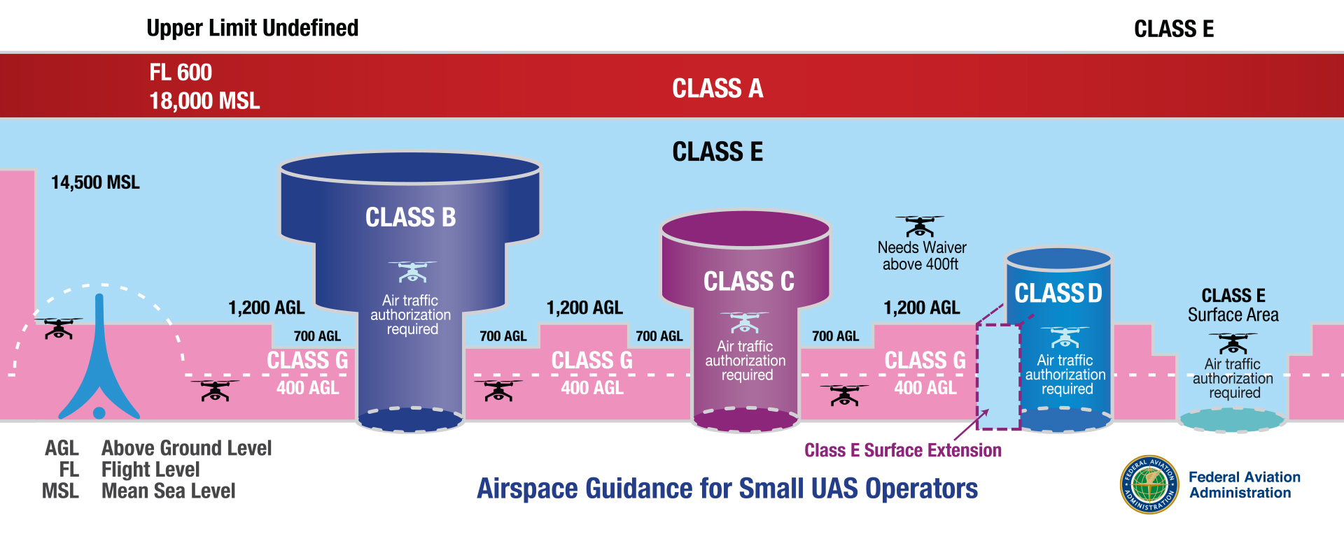
First, the answer is, yes, you can fly your drone near small airports in uncontrolled airspace. Only airports located in Class A, B, C, D, & E2 controlled airspace require LAANC authorizations to operate near or around. Many smaller municipal, regional, executive airports around the country are located in Class G uncontrolled airspace, meaning you do not need a LAANC authorization to operate near or around them. Some small airports are located under Class E controlled airspace but do not require prior authorization in order to operate near them since the controlled airspace starts at 700 ft. AGL. There are multiple types of Class E airspace, only one of which, Class E2 requires a LAANC authorization in order to operate from the surface to 400 ft. AGL. Read more about Class E airspace here.
The FAA’s official statement on their website is:
“For [drone] flights near airports in uncontrolled airspace that remain under 400’ above the ground, prior authorization is not required.”
Below are three tips to help you ensure your operation is safe and compliant while operating a UAS near an airport in uncontrolled airspace:
1. Always check the FAA’s B4UFLY app or web for specific information about the airspace you plan to operate in.
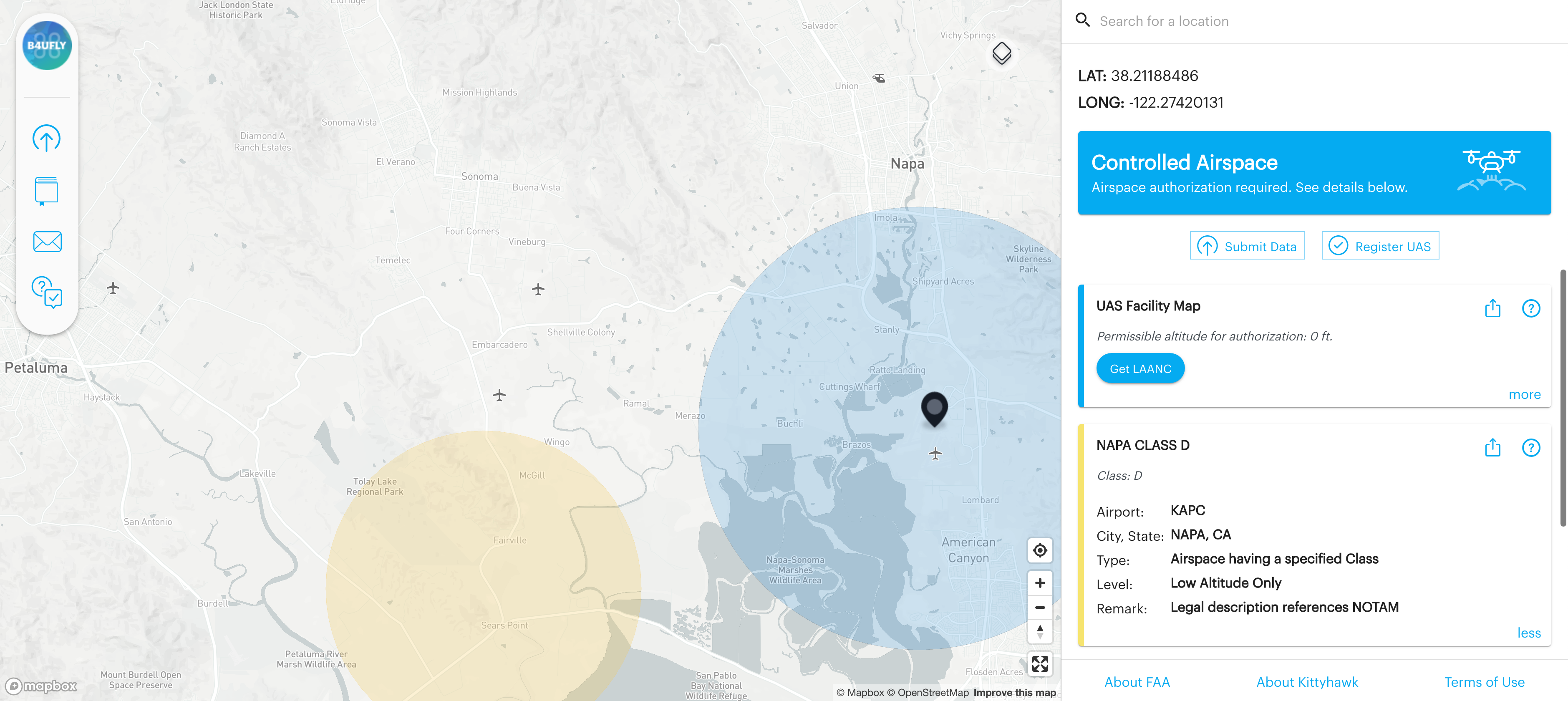
When looking at the map on the B4UFLY platform, you will see grey airplane icons indicating an airport at that designated location. If an airport is located in controlled airspace, the airplane icon will be surrounded by a colored circle indicating what class of airspace it is. Looking at the map for the Napa, California area around KAPC, you will see the airplane icon and that the area surrounding it is colored light blue in a five-mile radius to indicate it is in Class D controlled airspace.
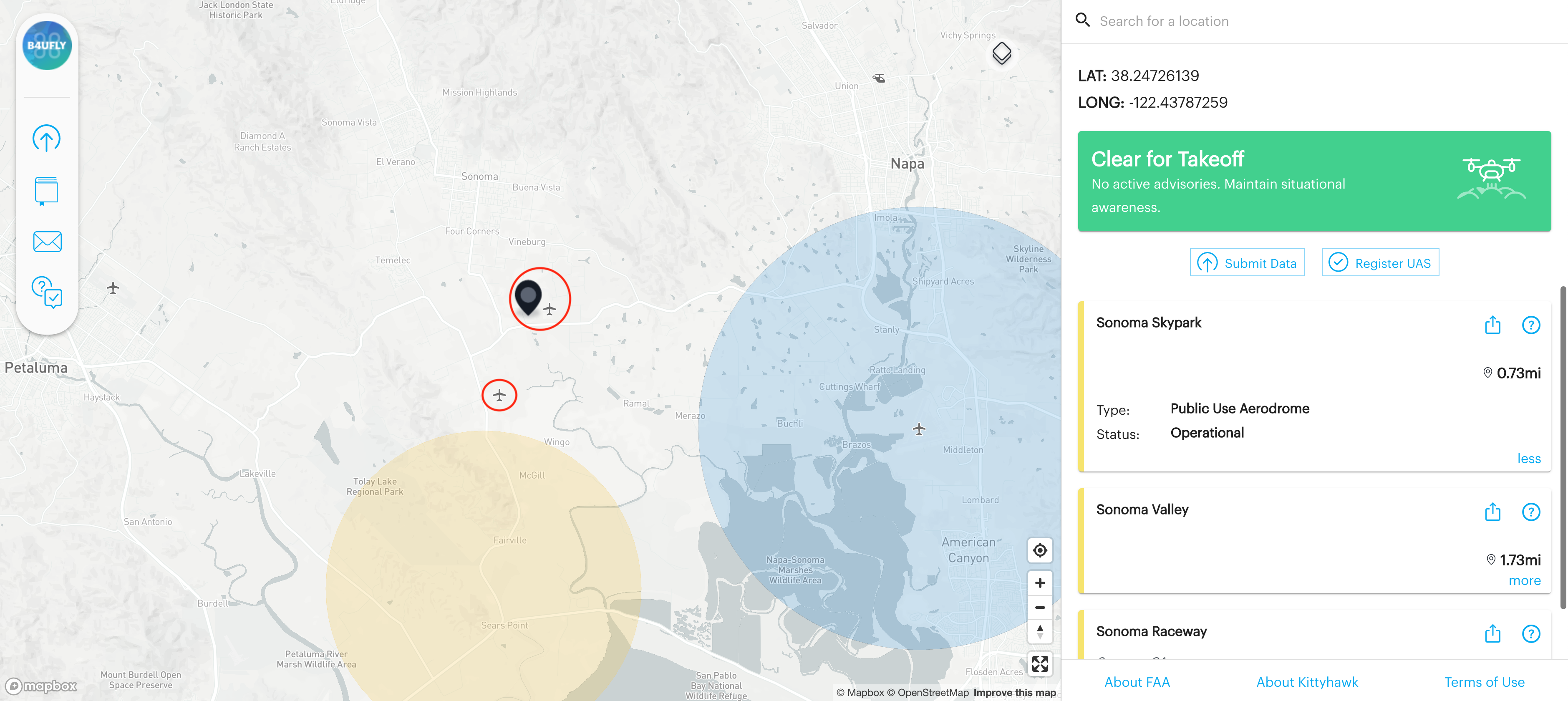
Further outside of Class D airspace around KAPC, there are two airplane icons on the map. When you click near them on the right-hand column, airspace advisory information for each appears, see the screenshot below. These two airports, seen below, are Sonoma Skypark and Sonoma Valley Airport, both are operational public use aerodromes. You will see unlike KAPC, Sonoma Skypark and Sonoma Valley do not have colored circles surrounding them. This is because they are located in Class G uncontrolled airspace and do not require an operator to have FAA authorization to operate a drone up to 400 ft AGL. When you are located in uncontrolled airspace on the B4UFLY platform, you will see a ‘Clear for Takeoff’ green box in the advisory bar info. This means you are clear to fly without the need for an FAA authorization.
2. When flying in these areas, remote pilots and recreational flyers must be aware of and avoid traffic patterns and takeoff and landing areas.
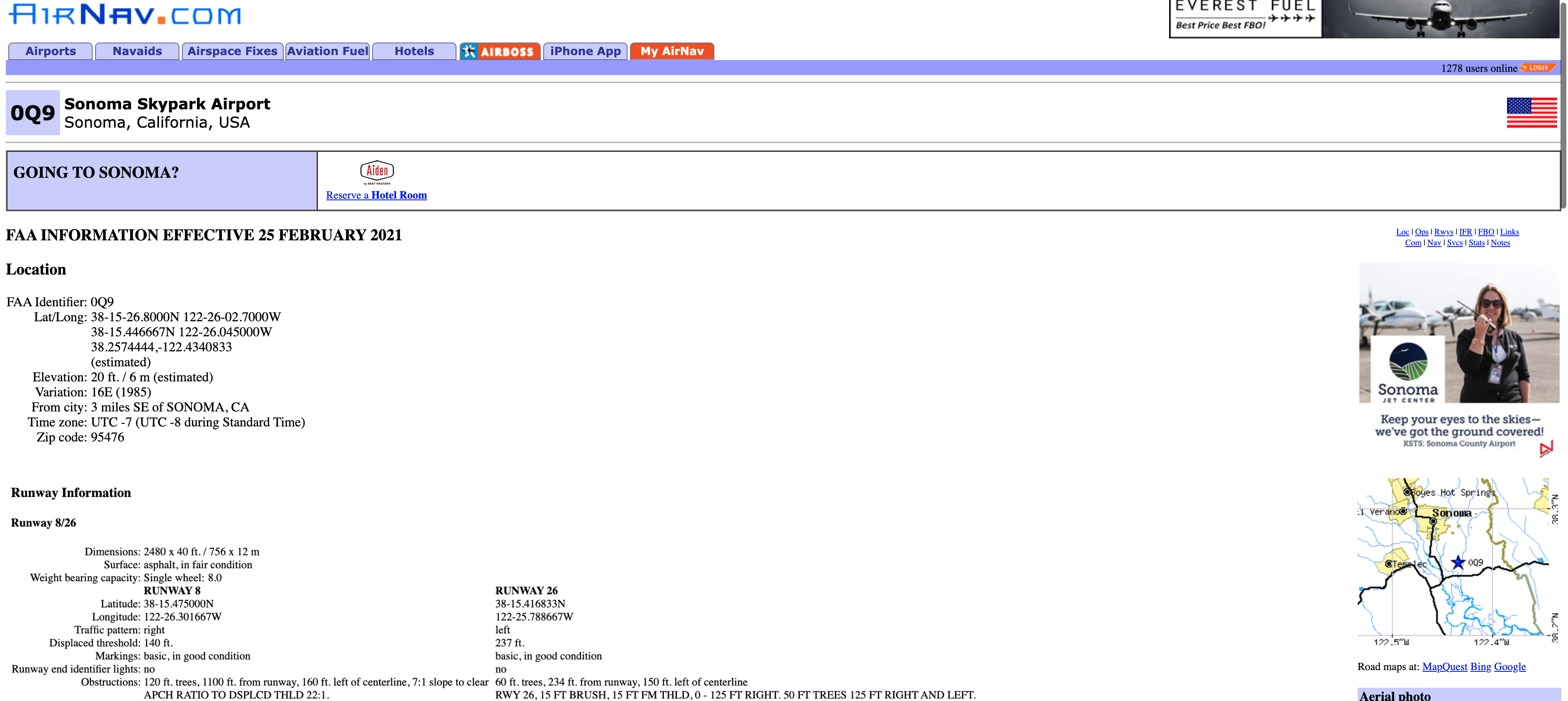
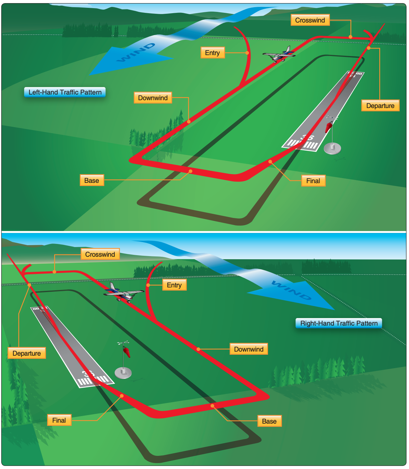
While airport traffic and landing pattern information isn’t something most Part 107 UAS pilots may be familiar with, it’s important to understand this information specific to the small airport you will be operating near prior to beginning your operations. If you will be returning to a location near a busy small airport frequently to operate an sUAS, I recommend using airnav.com, to familiarize yourself with the airport’s traffic patterns and other useful information that can help you fly safely. In looking at the airnav.com page for Sonoma Skypark, we can see it is a privately owned aerodrome open for public use that has two runways, runway 8 with a right traffic pattern and runway 26 with a left traffic pattern. Also, you can view the sectional map for this area here as well.
See the figures below for examples of a right-hand and a left-hand traffic patterns at small airports.
3. A drone must not interfere with operations at the airport and must yield the right-of-way to all other aircraft.
If your operations must be conducted in the traffic pattern for a small airport, remember that you must always yield the right of way to manned aircraft. So if you see a plane approaching for landing at the airport, you must either land your UAS or change your position or altitude to safely avoid the manned aircraft’s flight path.
The most important thing for you to consider if you are flying near an airport in uncontrolled airspace is:
- Is it busy?
- Is it deserted?
- Is it a busy time of day for landings and take-offs?
- What is the air traffic like?
- What is the traffic pattern for this airport?
Understand that, small airports in Class G uncontrolled airspace and all types of Class E (excluding Class E2) controlled airspace do not require FAA authorization for drone operations up to 400 ft AGL but you should have extra vigilance to safety precautions during these operations. The B4UFLY platform provides an essential tool for all US drone operators to access, for free, real-time airspace data to ensure the desired operation is safe and FAA-compliant before taking flight. If you haven’t already, we encourage you to download the B4UFLY app or check out B4UFLY on the web, to start planning your next UAS operation. As always, fly safe and fly often!


