Understanding what types of airspace different colored map layers indicate on the B4UFLY and Air Control Platform.
As the Remote PIC, knowledge of the regulations for the type of airspace you wish to operate in is essential for safe and compliant operations. For US drone pilots, the best practice for situational awareness is to check the airspace you intend to operate in on the FAA’s B4UFLY platform before take-off. A very common point of confusion for UAS operators is understanding the map layers, what each color indicates on the map, and then understanding where you can and can not operate your drone. Whether a pilot is looking for clarification on FAA compliance of operations near a small airport in uncontrolled airspace or to understand the different types of special-use airspace and how to identify them on the map, keep reading for an explanation of how each type of airspace is represented on the map and regulations on drone operations for each type of airspace on the B4UFLY and Air Control platforms.
Now let’s break down what type of airspace each map layer color indicates on the map.
Types of Airspace by Color
1. Grey Airplane or Helicopter icon with no color surrounding = Class G uncontrolled airspace
The airplane and helicopter icon indicate areas on land or water intended to be used either wholly or in part for the arrival, departure, and surface movement of aircraft/helicopters in controlled and uncontrolled airspace. Drone operations in Class G uncontrolled airspace are permitted without an FAA LAANC authorization up to 400 feet AGL. When a grey airplane and helicopter icon is seen on the map without a circle surrounding it, that indicates a public aerodrome, helipad, or airport in Class G uncontrolled airspace as seen in the screenshot below.
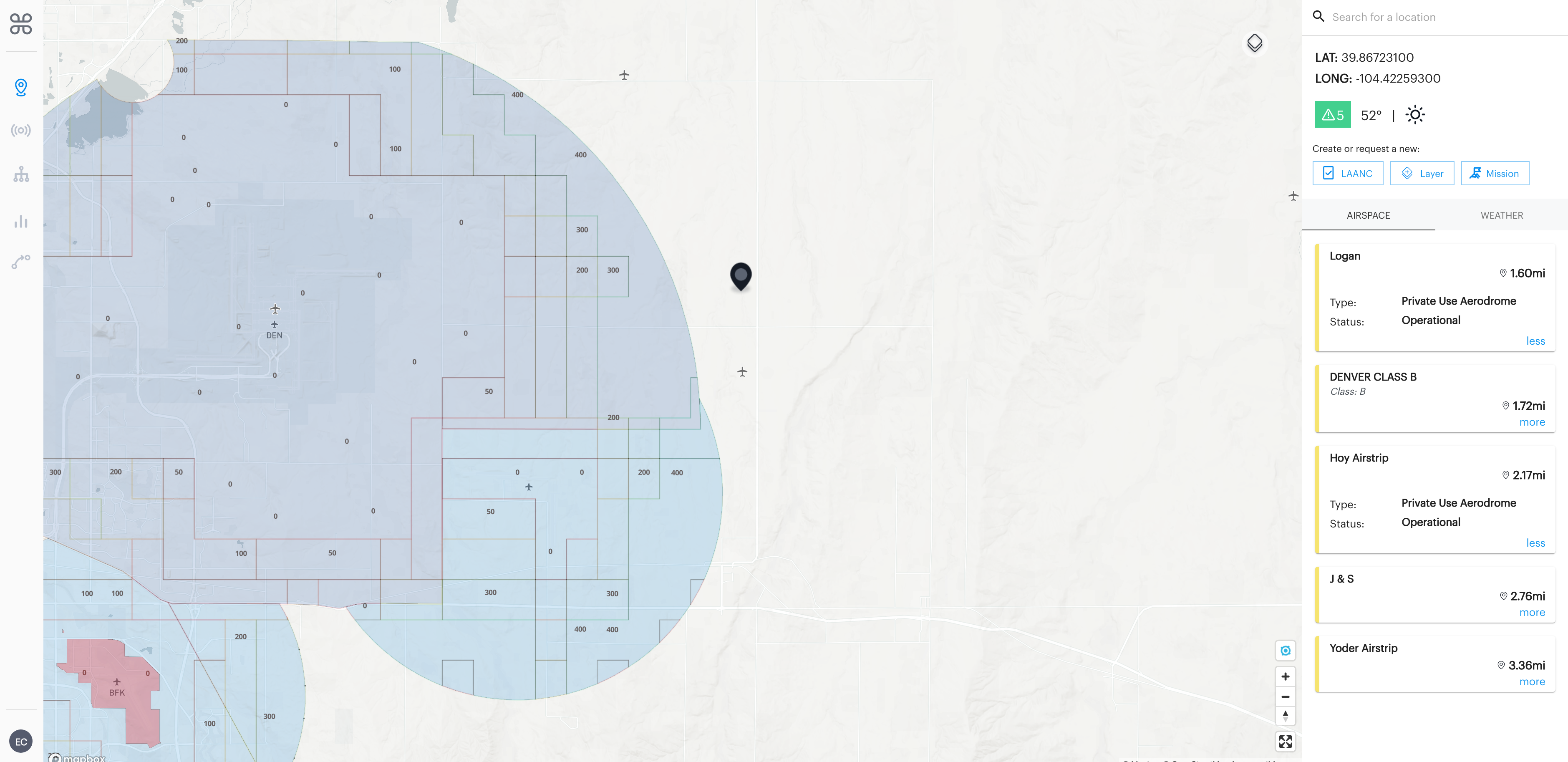
In the screenshot above, you will see Logan and Hoy Airstrip both have a grey airplane icon on the map indicating that they are public aerodromes located in Class G uncontrolled airspace. This means to operate a drone up to 400 feet AGL near Logan and Hoy Airstrip you do not need an FAA LAANC authorization because they are in Class G uncontrolled airspace. Read more about operating a drone near airports in uncontrolled airspace here.
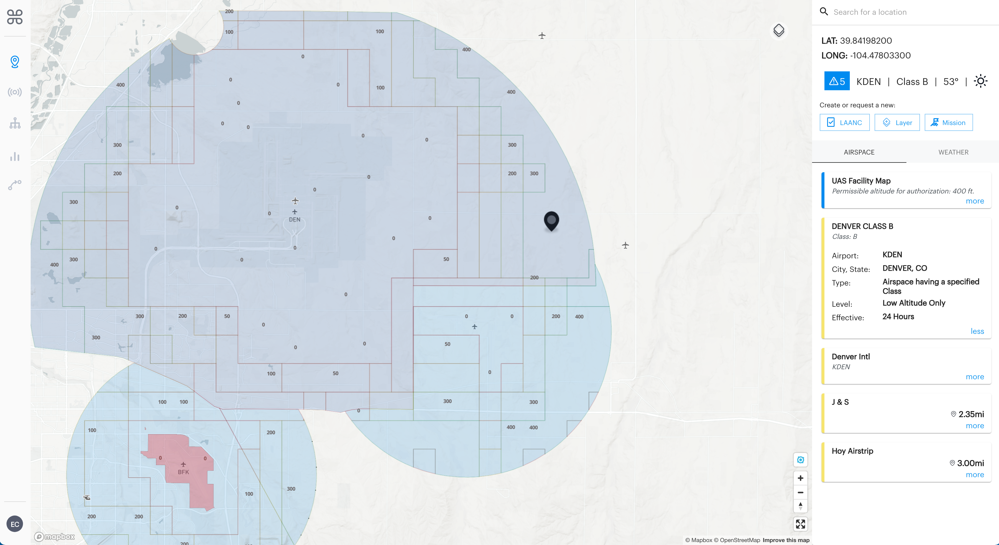
2. Dark Blue = Class B controlled airspace
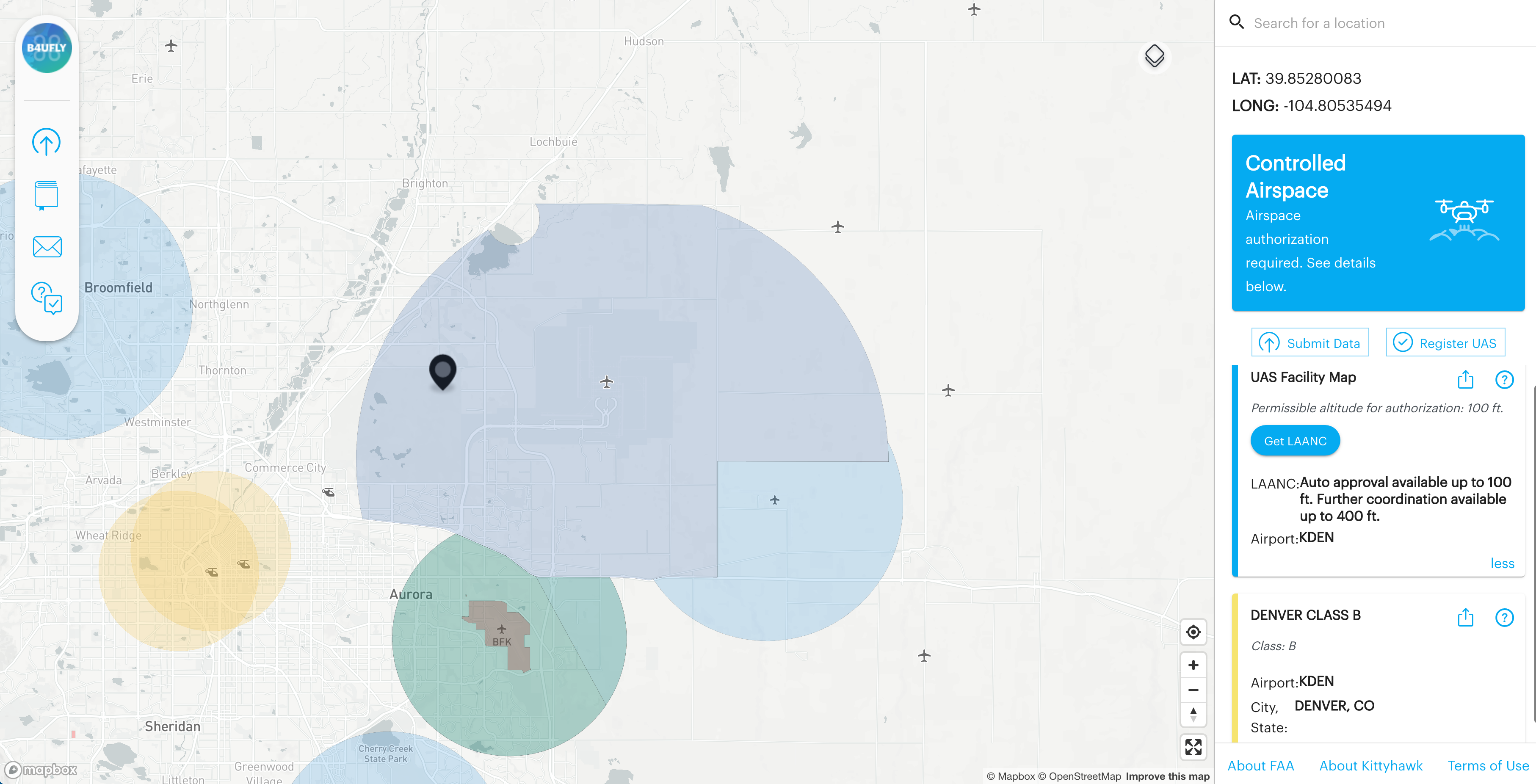
Class B airspace is generally airspace from the surface to 10,000 feet MSL surrounding the nation’s busiest airports in terms of airport operations or passenger enplanements. An example of Class B airspace is KDEN in Denver, Colorado which is surrounded in a 10-mile radius of the airport by a dark blue circle indicating the Class B controlled airspace on the map. To operate a drone anywhere in this airspace, you will need a LAANC authorization.
When looking at the Denver, Colorado area, in the screenshot below, you can see the difference in coloration as KDEN is located in Class B airspace so the airport is surrounded by a darker blue circle and then Front Range airport (KCFO) is located in Class D airspace so the surrounding circle is light blue. To operate a drone anywhere in this airspace, you will need a LAANC authorization.
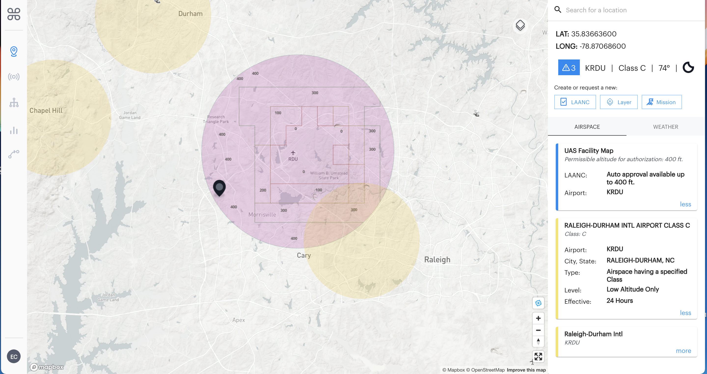
3. Purple = Class C controlled airspace
Class C airspace is generally airspace from the surface to 4,000 feet above the airport elevation (charted in MSL) surrounding those airports that have an operational control tower, are serviced by a radar approach control, and have a certain number of IFR operations or passenger enplanements. Raleigh-Durham International Airport (KRDU), seen in the screenshot below is an airport located in Class C controlled airspace as indicated on the map by the purple circle surrounding the airport in a 5-mile radius. To operate a drone anywhere in this airspace, you will need a LAANC authorization.
4. Light Blue = Class D controlled airspace
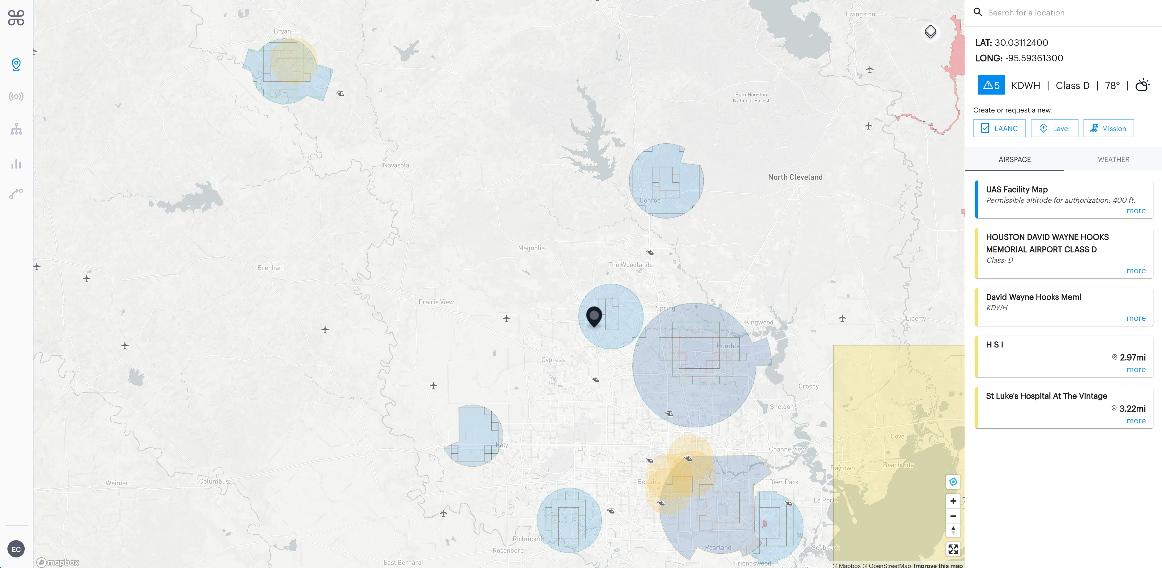
Class D airspace is generally airspace from the surface to 2,500 feet above the airport elevation (charted in MSL) surrounding those airports that have an operational control tower. Houston David Wayne Hooks Memorial Airport, seen in the screenshot below is an airport located in Class D controlled airspace as indicated on the map by the light blue circle surrounding the airport in a 5-mile radius. To operate a drone anywhere in this airspace, you will need a LAANC authorization.
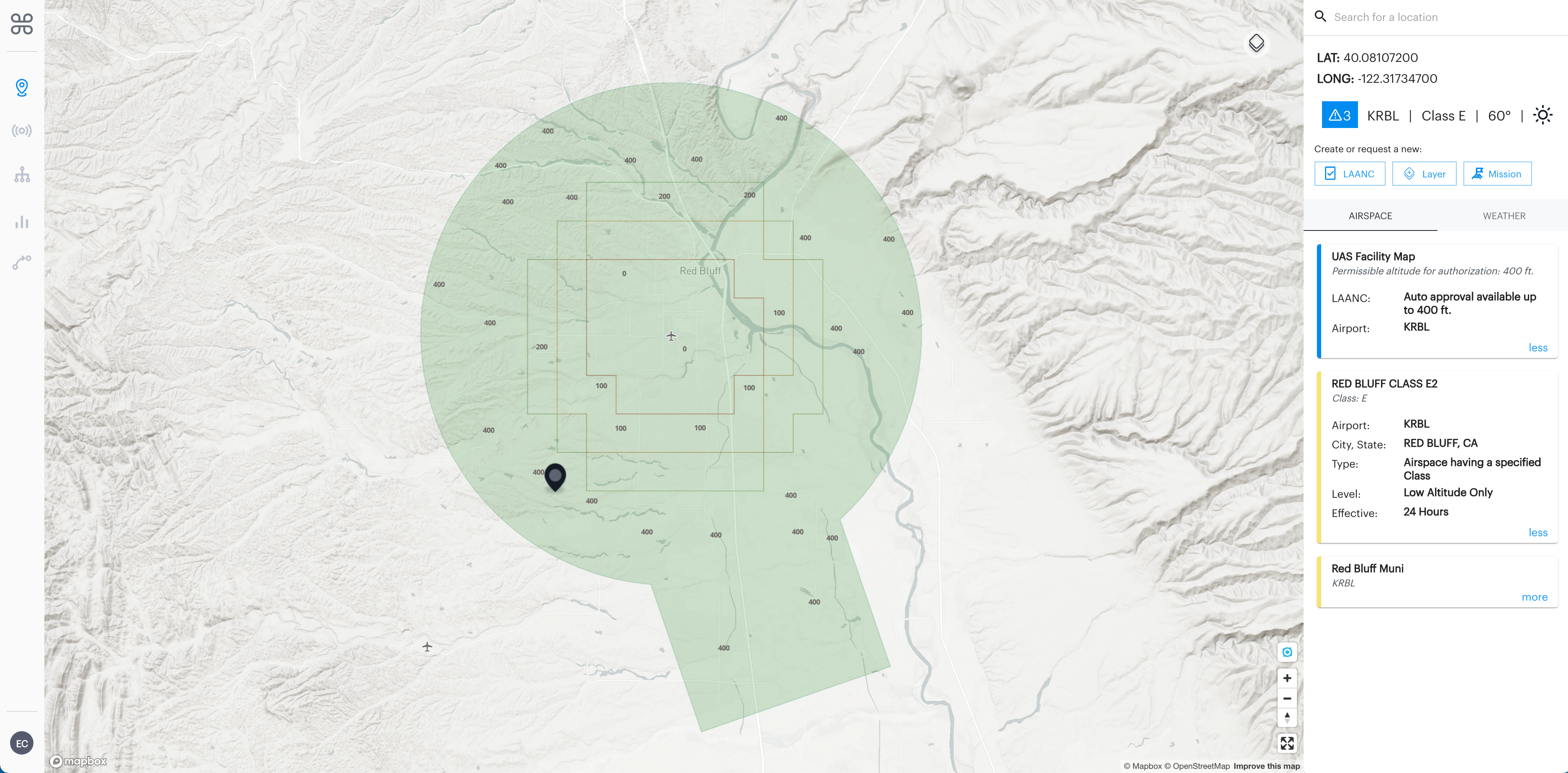
5. Green = Class E2 controlled airspace
Class E2 airspace is the one type of Class E airspace that affects UAS operations as it begins at the surface and extends up to 14,500 feet MSL. This means all drone operations up to 400ft AGL located in Class E2 controlled airspace require a LAANC authorization prior. The remaining types of Class E airspace are still considered controlled airspace but do not require prior authorization in order to operate up to 400 ft AGL because the controlled airspace starts at 700 ft. AGL. Red Bluff Airport, seen in the screenshot below is an airport located in Class E2 controlled airspace as indicated on the map by the green circle surrounding the airport in a 5-mile radius. To operate a drone anywhere in this airspace, you will need a LAANC authorization.
*Note, you will not find Class A airspace on the map as it is largely irrelevant for hobbyist or commercial drone operations, as it starts at 18,000 feet.
UAS Facility Map Grids and Applying for LAANC
All Class B, C, D, and E2 controlled airspace that are LAANC available will be colored as explained above. Click anywhere in the controlled airspace you wish to operate in to view the permissible altitude for auto-authorization with LAANC in the right-hand (desktop) or bottom (mobile) airspace advisory bar. Under ‘UAS Facility Map’ in the airspace advisory bar you will see the permissible altitude you can get a LAANC authorization for. As seen in the screenshot below, KDEN airport is located in Class B airspace. The location I have selected has an auto-approval available up to 100 ft AGL and further coordination available up to 400 ft as indicated in the blue ‘UAS Facility map’ airspace advisory box on the right.
*To note, the B4UFLY platform does not show the UAS Facility Map grid lines as seen on the Aloft (formerly Kittyhawk) and Air Control platforms. Though all the same UASFM information can be seen in the airspace advisory bar. To apply for a LAANC authorization from the B4UFLY platform, simply click the ‘Get LAANC’ button in blue and log into the Aloft app to apply for free, near-instant authorization up to UASFM permissible altitude to operate in controlled airspace surrounding 731 airports across the country.
6. Controlled airspace where LAANC is not available
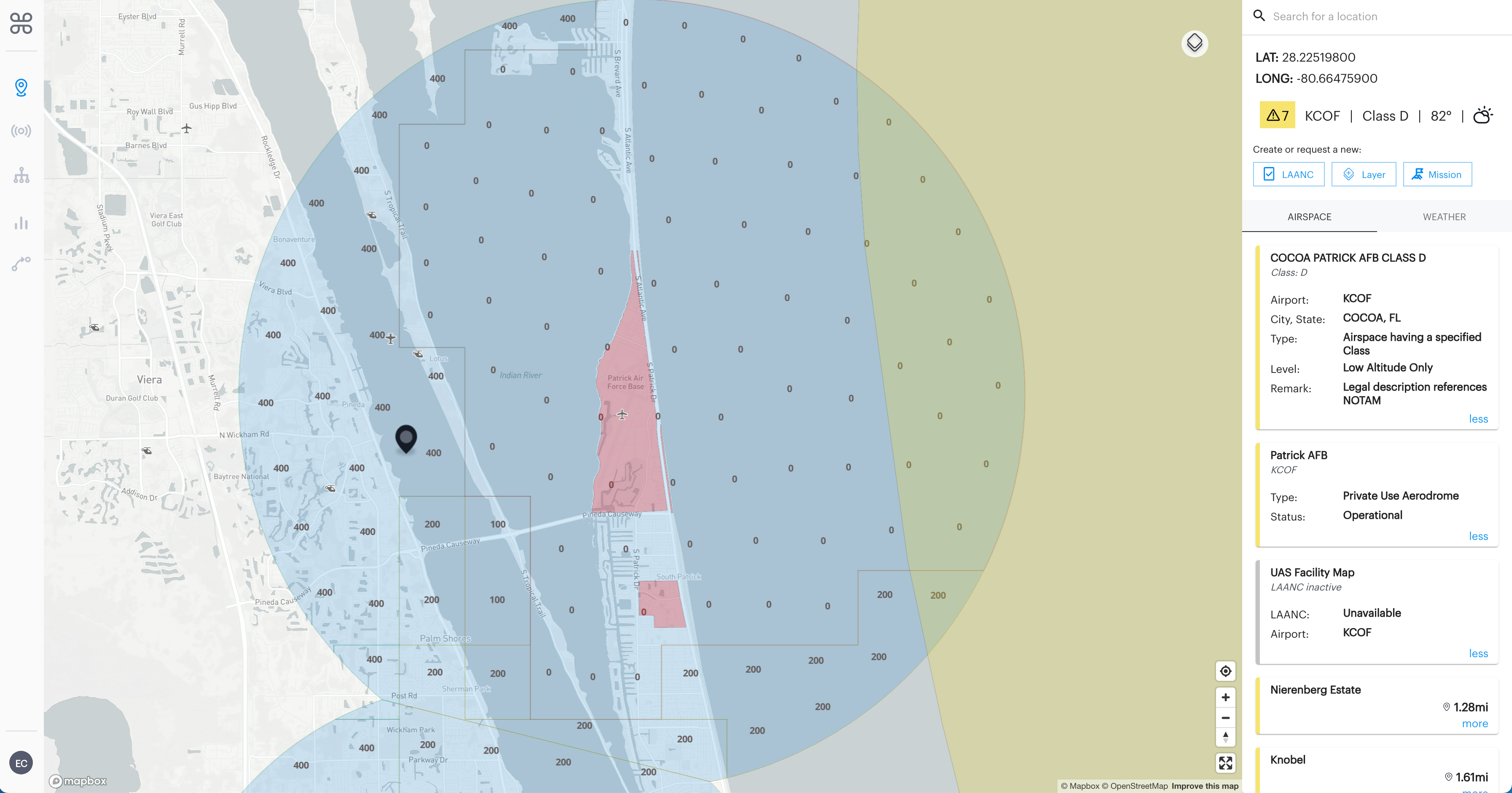
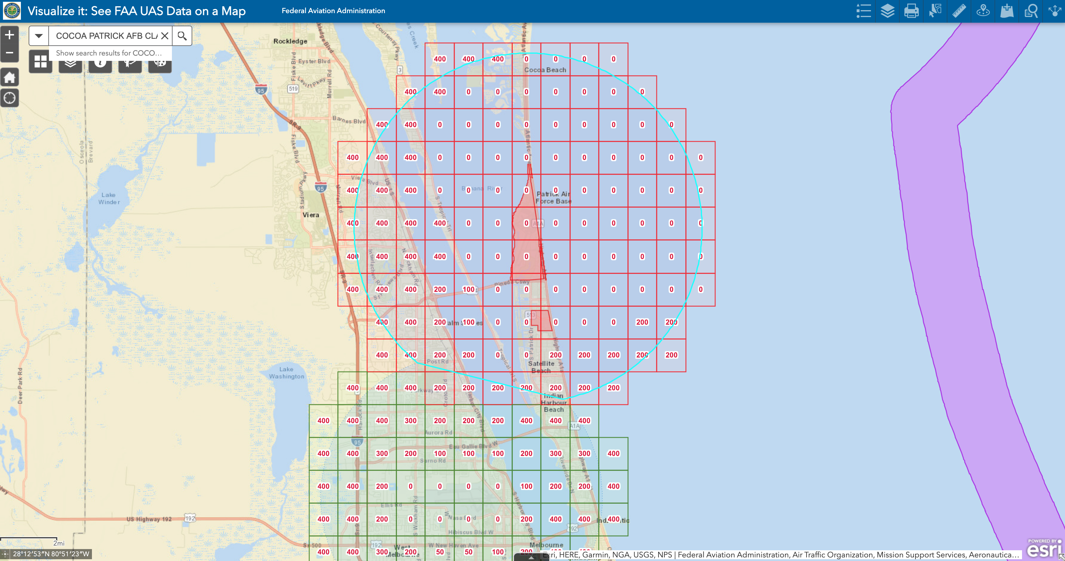
Airports in controlled airspace where LAANC is NOT available will be surrounded by the same color circle as all other airspaces of that type but will display a grey ‘LAANC unavailable UAS Facility Map’ airspace advisory. As you can see in the screenshot of KCOF airport in Florida, it is located in Class D controlled airspace so the airport is surrounded by a light blue circle in a 5-mile radius just like all other Class D airspace is on the map. But the main difference is in the airspace advisory bar, you will see a grey LAANC unavailable advisory letting you know you can not use LAANC to operate in this controlled airspace currently. The second screenshot above shows how KCOF looks on the FAA’s Visualize It database of the UAS Facility Maps. You can see that the controlled airspace surrounding KCOF is shown in red meaning LAANC is not currently available there. Operating a drone in this controlled airspace is possible but you will have to apply for an airspace authorization via the FAA Drone Zone instead of using LAANC. This process can take some time so planning ahead if you need to operate in controlled airspace where LAANC is not available is highly recommended. Read more about applying for airspace authorizations and waivers in the FAA Drone Zone here.
7. Yellow
Airspaces colored yellow on the map will also be colored yellow in the airspace advisory bar on the right (desktop) or below (mobile). This indicates that drones may be allowed in this airspace but to first check the airspace advisory bar for further detail and to use caution during operations in this airspace.
-
Stadiums
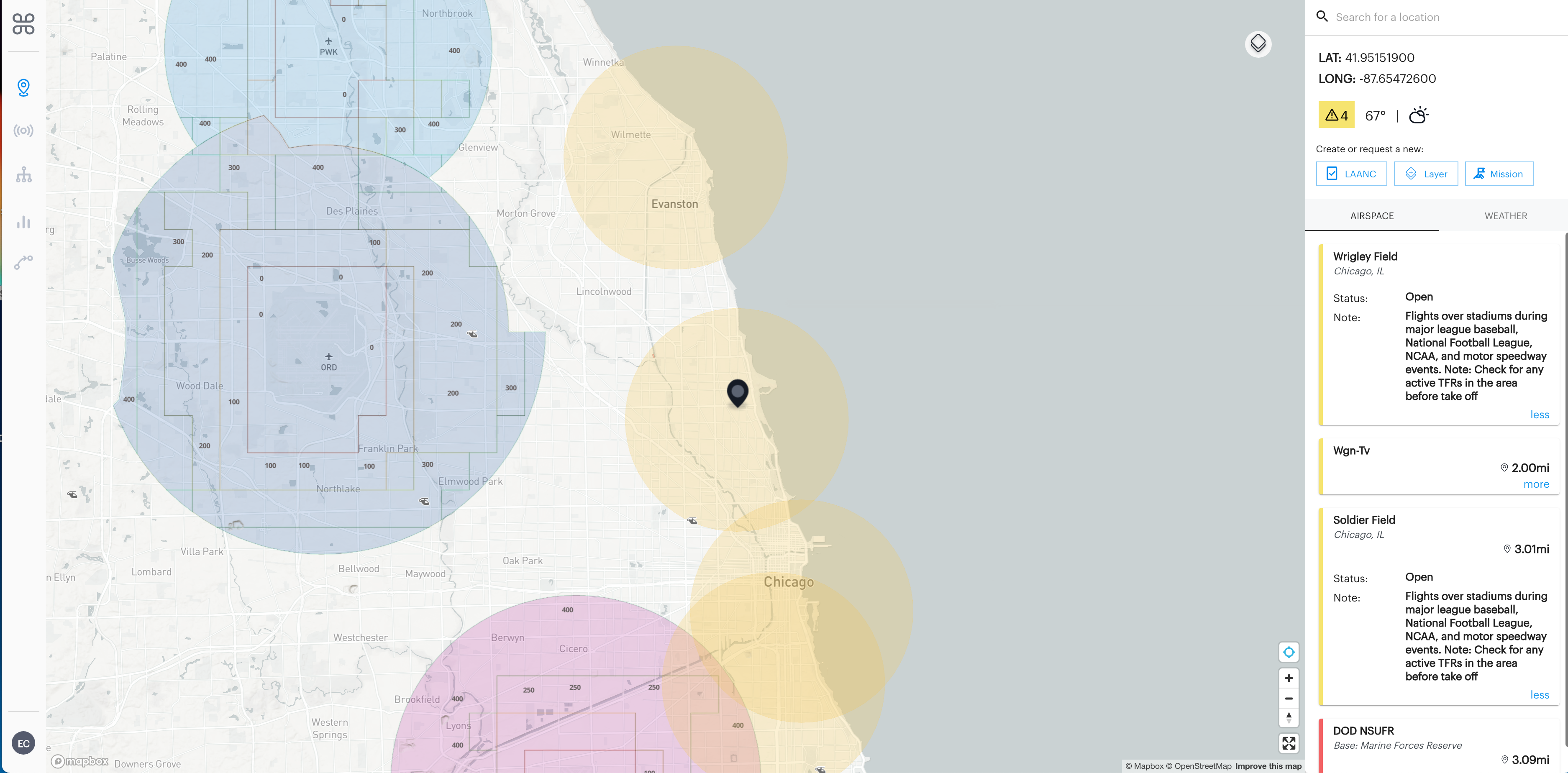
Drone operations over stadiums during Major League Baseball, National Football League, NCAA, and motor speedway events are prohibited. As you can see in the screenshot above, in the Chicago, Illinois area there are three yellow circles on the map surrounding Ryan Field, Wrigley Field, and Soldier Field in a 5-mile radius of the stadiums. If active sporting events are taking place at these locations then drone operations are prohibited. So if you’d like to operate in an area that is surrounding a stadium, always check for active TFRs in your operation area before takeoff.
-
Local Layer
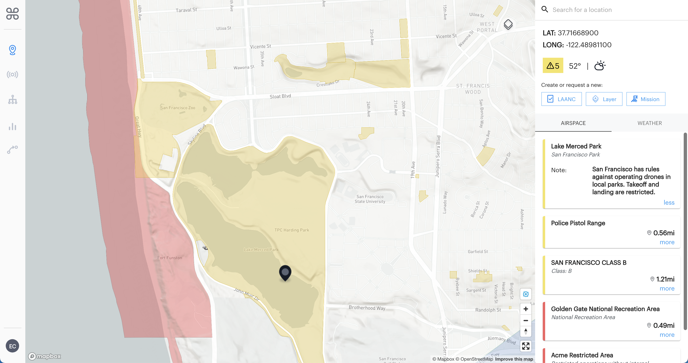
Local advisories such as drone restrictions for local parks and recreational areas are identified in yellow on the map. Lake Merced Park in San Francisco, in the screenshot above, is an example of a local layer you may see on the map. Under ‘Notes’ for this advisory, you can see that the city of San Francisco has rules prohibiting the operation of drones in all local parks.
If you represent a state, city, or local park that has ground rules pertaining to drone operations that is currently missing from the map, we encourage you to add your data to the B4UFLY platform by contacting us at b4ufly@aloft.ai.
-
Special Use Airspace- Type: Military Operation Area (MOA)
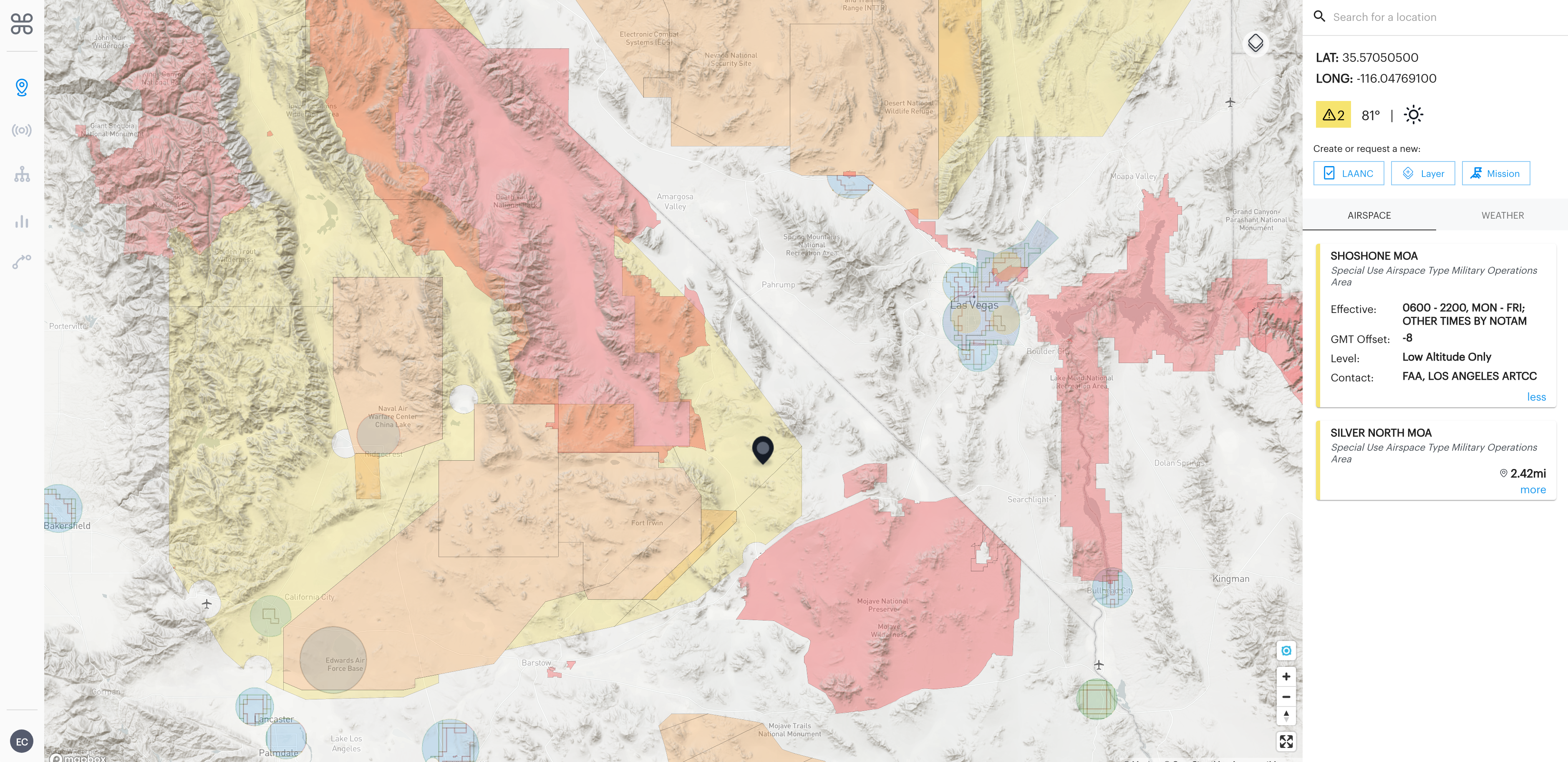
Military Operation Areas or MOAs consist of airspace with defined vertical and lateral limits established for the purpose of separating certain military training activities from other aircraft traffic. In the screenshot above, you will see that Shoshone Military Operations Area is colored yellow to indicate if you are operating a drone anywhere in this yellow area to exercise extreme caution as military activity could be conducted anytime between 6 am and 10 pm, Monday through Friday or during other times by NOTAMs.
8. Light Orange = Special Use Airspace- Type: Restricted
Airspaces colored light orange on the map will be colored yellow in the airspace advisory bar on the right (desktop) or below (mobile).

Areas where drones and other aircraft are not permitted to fly without special permission. Restricted areas are areas where operations are hazardous to nonparticipating aircraft and contain airspace within which the flight of aircraft, while not wholly prohibited, is subject to restrictions. So operating a drone anywhere in this orange area would be subject to restrictions and require the operator to contact the control facility at Edwards Airforce base for more information before takeoff.
9. Red
Airspaces colored red on the map will be colored red as well in the airspace advisory bar on the right (desktop) or below (mobile). This indicates that drone operations are prohibited in this airspace.
-
Critical Infrastructure/ National Security UAS Flight Restrictions (NSUFR)

Security Sensitive Airspace Restrictions that prohibit drones from flying over designated national security-sensitive facilities like military bases, national monuments, etc. As seen in the screenshot above, Hawthorne Army Depot is a DOD NSUFR area where drone operations are prohibited.
-
Temporary Flight Restrictions (TFR)
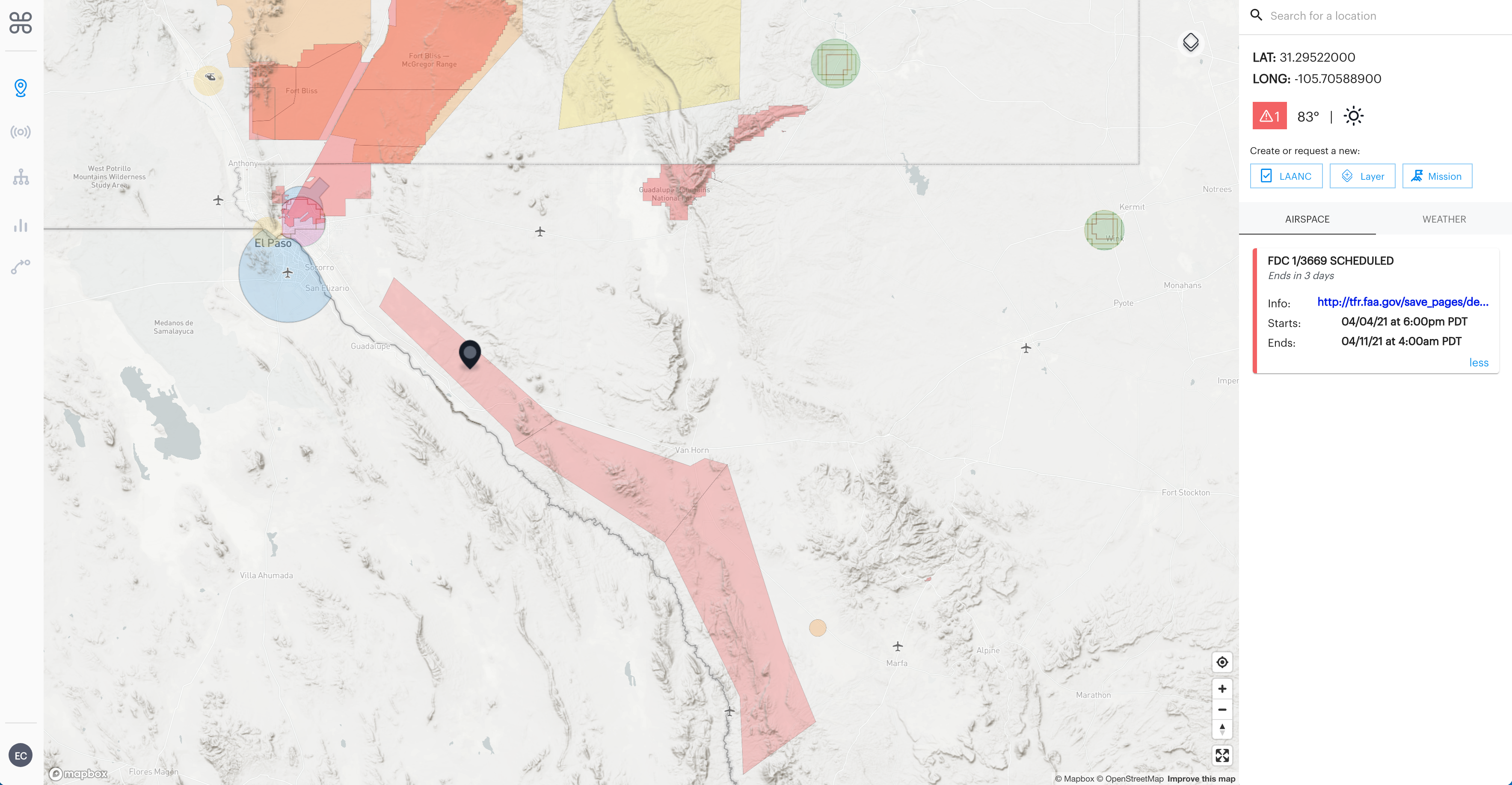
Area restricted to air travel due to a hazardous condition, a special event, or a general warning for the entire FAA airspace. Note: Depicted TFR data may not be a complete listing. For the latest information, call your local Flight Service Station at 1-800-WX-BRIEF. The screenshot above is an example of a TFR starting 04/04 at 6 pm and effective till 04/11 at 4 am. This means drone operations taking place during this time period anywhere in this red area on the map are prohibited. Under ‘Info’ in the airspace advisory of this TFR, you can click the blue link to navigate to the FAA’s TFR database for more information.
-
National Parks
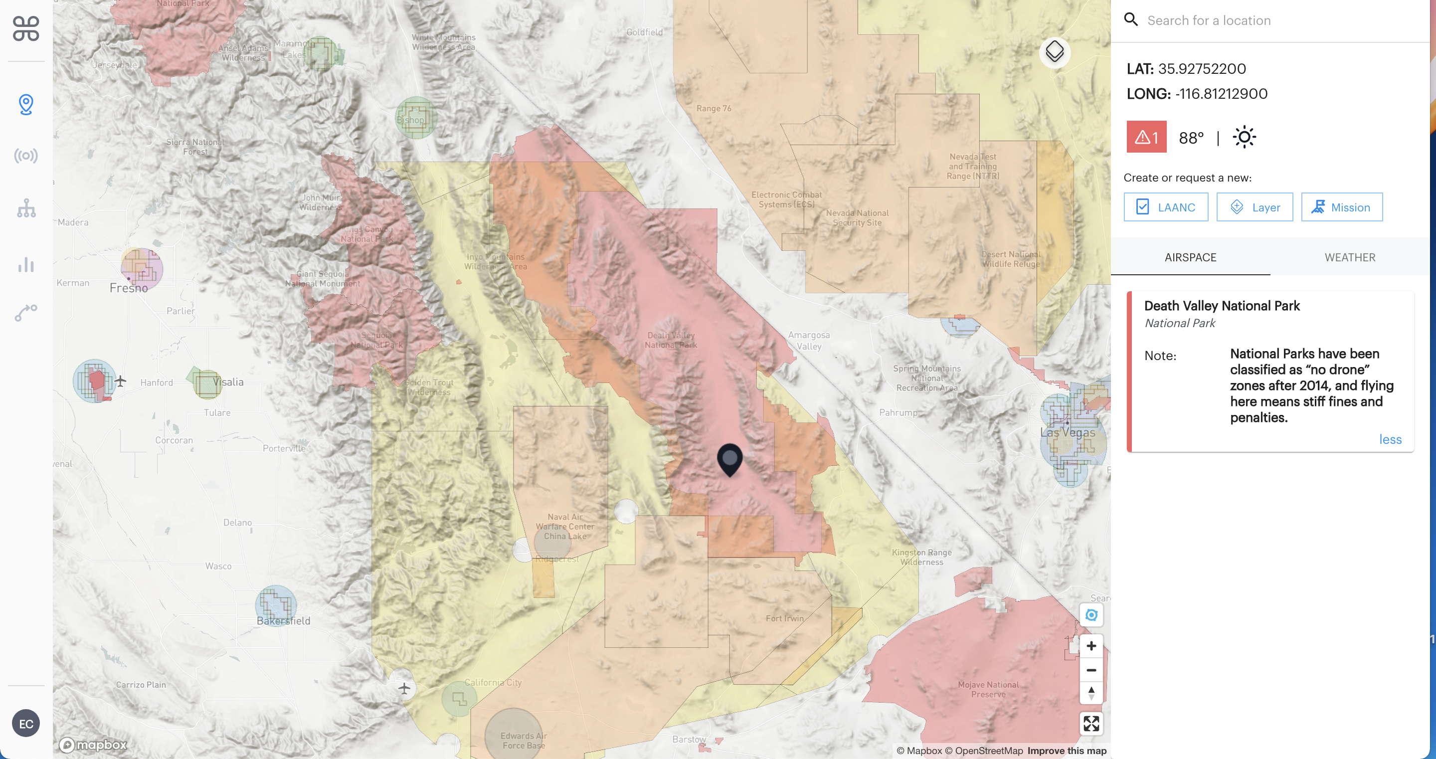
National Parks have been classified as “no drone” zones after 2014. Flying here means stiff fines and penalties. In the screenshot above, see the entire Death Valley National Park is colored red on the map to indicate drone operations throughout the national park are prohibited.
-
Special Use Airspace- Type: Prohibited
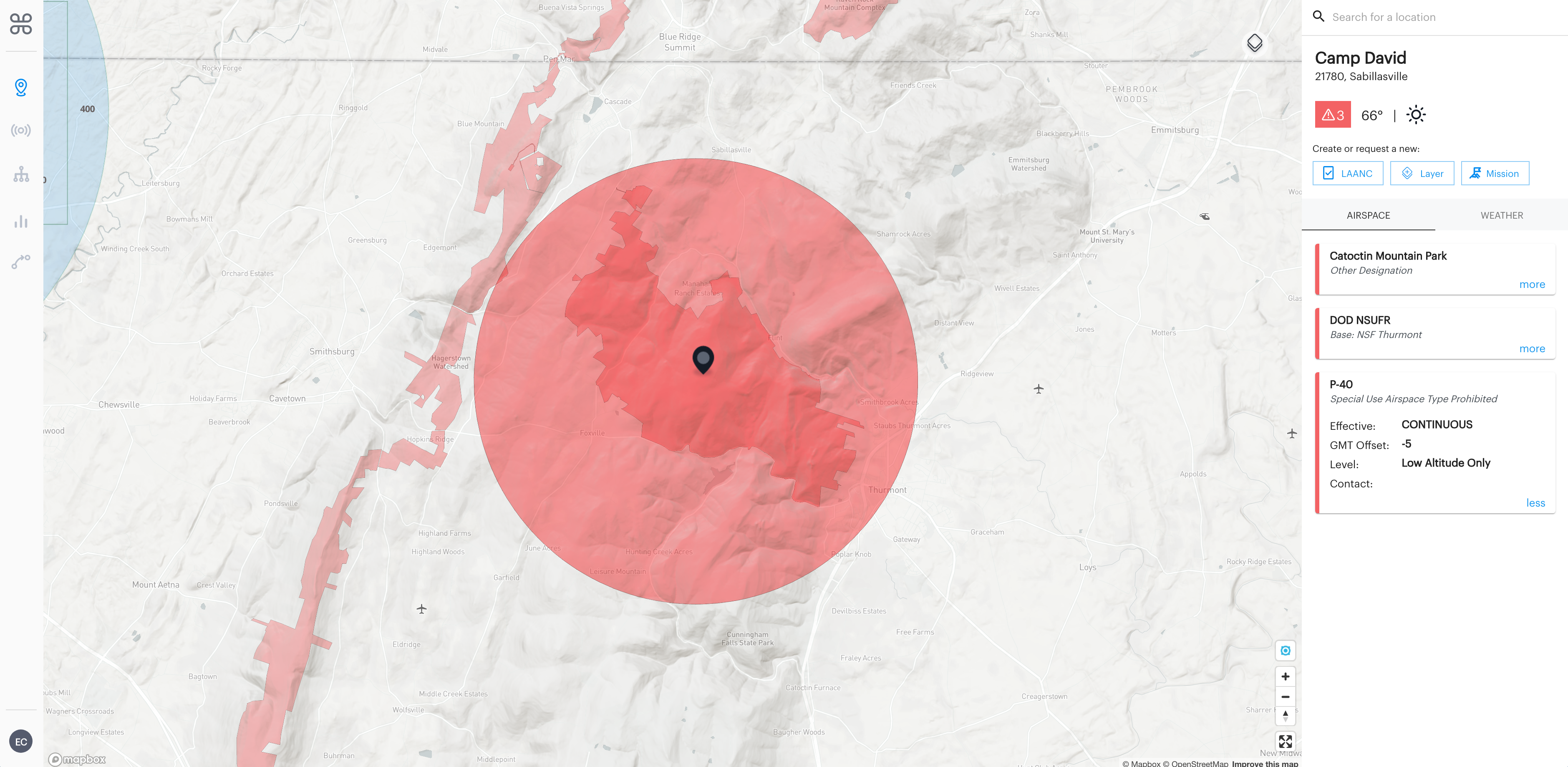
Prohibited areas contain airspace of defined dimensions within which the flight of any type of aircraft, manned or uncrewed is prohibited. Such areas are established for security or other reasons associated with the national welfare. As seen in the screenshot above, Camp David in Maryland is an example of a prohibited type of special use airspace for drones.
There are many different types of airspace in the NAS and understanding where you can and can not conduct drone operations safely is an essential part of being a drone pilot. Tools like the B4UFLY and Air Control platform make it simple for UAS pilots to plan flights to ensure 100% safety and compliance for every flight. I hope this explanation helps clarify how to understand the map layers better on the B4UFLY and Air Control platforms. If you have any questions, please feel free to reach out at team@aloft.ai.


